
VP08597-12h 6150x4100 pixels 1 frame 16 shot focus stack blend a6700 56mm
enlarged vertical slice view image text section
NEXT: Page 9 Sonoma Coast State Beach 5/20
2026 Trip Chronicles: Contents
Humboldt Redwoods State Park 5/8 2of2
Sonoma Coast State Beach 5/14
Up at dawn on Friday May 8, 2026, I was soon packed up and on the US101 highway road south. In a few minutes reached the exit to Clam Beach County Park where I stopped for about a half hour. Vegetation was surprisingly dry so didn't bother with any photography. Instead, continued south to Eureka where I stopped briefly for fresh ice for the cooler and some perishable food from a Walmart. Then continued south and stopped in Fortuna for a bit cheaper gasoline at $5.89/gallon than I'd noticed in Eureka.

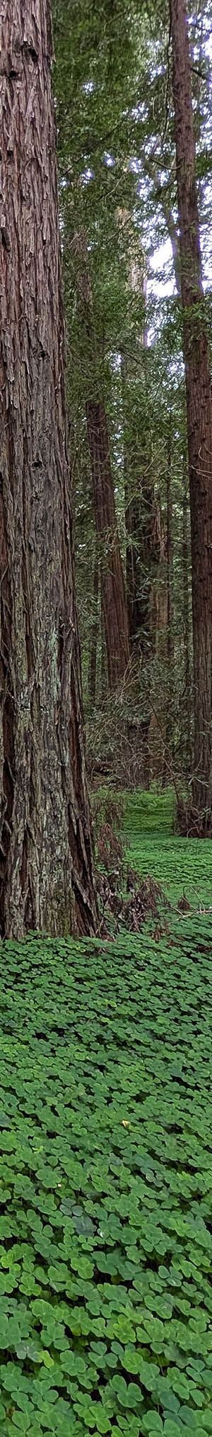
AL-PXL-9645 2720x2048 pixels 1 frame Pixel 10 Pro 2.0mm
enlarged vertical slice view
After reaching the Pepperidge area of Humboldt Redwoods State Park, I set out down one of the dim paths and was surprised at how much better green the redwood sorrel, Oxalis oregana, looked and with more white flowers, than on previous visits near the end of May. At 8:56am worked the above image showing how the forest ground cover looks in this limited area, that is unique among all other redwood parks. Although redwood sorrel is common below all redwoods in parks, it is only in this section of the Eel River where fog is more common than further south where the sorrel tends to densely cover ground, logs, boulders, and anything else so. Lady fern, Athyrium filix-femina, in many areas tends to cover up the sorrel but in these coast redwood, Sequoia sempervirens, groves, are less dominant. The non-official narrow path at frame right is typical of the maze of use foot paths in these forest areas.
Humboldt Redwoods State Park home page

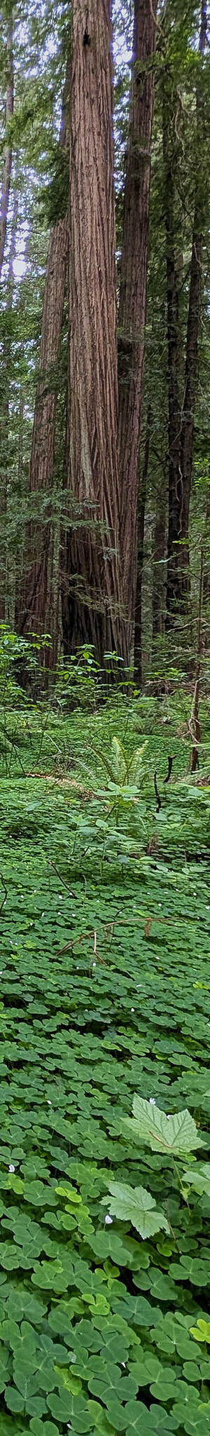
AL-PXL-4224 3264x2458 pixels 1 frame Pixel 10 Pro 2.0mm
enlarged vertical slice view
Another redwood sorrel and coast redwoods subject at 9:02am with a thimbleberry, Rubus parviflorus, plant at frame lower right and at mid frame cascara buckthorn, Frangula purshiana. Note the large still living redwood with its lower trunk burned by some ancient fire.

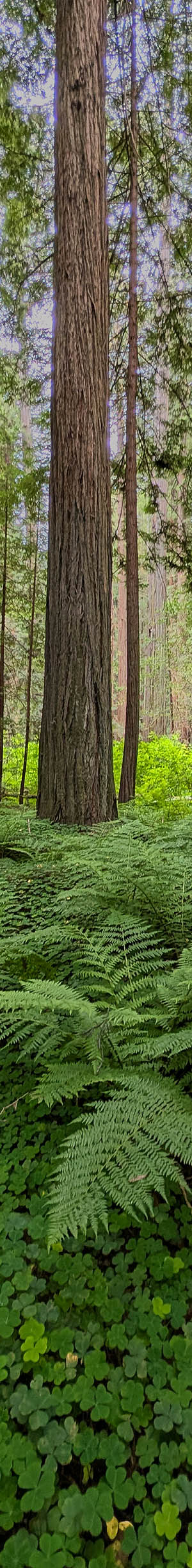
AL-PXL-30434 3264x2458 pixels 1 frame Pixel 10 Pro 2.0mm
enlarged vertical slice view
Another redwood sorrel, ladyfern, and coast redwoods subject at 9:11am.

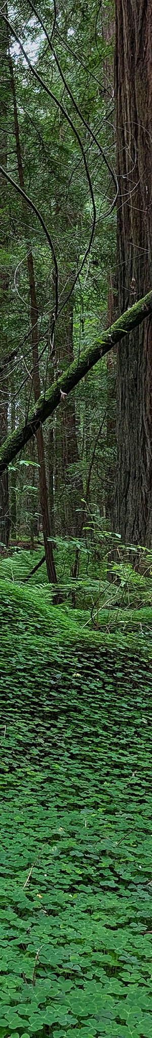
AL-PXL-4224 3264x2458 pixels 1 frame Pixel 10 Pro 6.9mm
enlarged vertical slice view
At 9:26am, worked the above uneven section, where sorrel has covered several logs beneath. A breeze was growing and the marine overcast was being replaced by harsh contrasting sun and shadows. So, my work in redwoods was over for the trip. I drove south US101 to Leggett where for hours, took Highway 1 southwest to Westport Beach, Fort Bragg, Mendocino, and by later afternoon Salt Point State Park. A much stronger than forecast before my trip northwesterly wind had arrived with sun increasingly piercing the marine overcast south of Fort Bragg. Salt Point was too dry to bother with, so continued on to Sonoma Coast State Beach. Although my potential subjects there, wet surf stones, were wind proof subjects, the wind was so strong, I would have had trouble from tripod vibration. So, feeling capable, continued driving the rest of 120 miles home via Petaluma, US101 into San Francisco, and south on I280. I chose a Golden Gate Bridge toll at $7.50, versus the free going east across Richmond Bay Bridge on I580, then I880, and all its unpleasant commute traffic.
Over the following week with much image post processing, researched other mélange geology shore areas of the North Coast and given a sunny, low wind forecast for Thursday May 14, decided on a road trip to at least the 65 miles to the Golden Gate National Recreation Area, the headlands of which, I had not previously explored, have mélange geology.
I was awake at 5am on Thursday May 14, 2026, and not feeling like more sleep was possible, got up, loaded gear into my car, and drove off north on I280, into San Francisco, across the Golden Gate Bridge, and into Marin County, where I took Highway 1 north to Muir Beach. That beach at 8:00am, turned out to be uninteresting. mélange yes, but without stones, just black sand. To reach the other two GGNRA beaches of interest, would require driving the dozen or so miles back to the north end of the Golden Gate Bridge where Bunker Road routes west to Rodeo Beach. Instead of gambling, I'd find mélange stones there, decided to drive Highway 1 north another 60 miles to the Sonoma Coast State Beach areas I knew for certain would have stone subjects. Thus, another 90 minutes driving that windy highway.
Google AI: The Sonoma Coast is primarily underlain by the Franciscan Complex, a chaotic geological unit formed by tectonic subduction. It consists of a highly sheared, crushed matrix of mudstone or sandstone containing a jumbled mixture ("mélange") of diverse, resistant "knockers" of greenstone, chert, blueschist, and serpentinite.
Tectonic Origins & Composition: The mélange along the Sonoma Coast is part of the Franciscan Central Terrane, created when the ancient Farallon Plate subducted beneath the North American Plate between 200 and 80 million years ago. As the tectonic plates collided, deep-sea sediments, ocean crust, and continental slope materials were scraped off the subducting plate and mashed together into an accretionary wedge.
The mélange consists of two distinct components:
The Matrix: A soft, easily erodible matrix of crushed shale, mudstone, and greywacke sandstone.
Exotic Blocks ("Knockers"): Resistant chunks of rock that survived the crushing process. These "swim" within the matrix and include:
Greenstone: Ancient seafloor basalt lava.
Chert: Highly colorful, silica-rich radiolarian deposits.
Blueschist: Distinctive blue metamorphic rocks formed under intense, high-pressure subduction zone conditions.
Serpentinite: California's state rock, which originated as oceanic upper mantle and often forms slick, polished shear zones.
By 9:45am, had reached the state park and a roadside pull-out parking area. I then hiked down to the un-obvious least difficult route down over a steep vegetated bluff face to a beach. I made my way down its unstable slope using my tripod for stabilizing support. At the bottom, was frustrated to find very few usual stone pile sections not covered by sand. Well, I worked 4 mediocre subjects and then decided to return to my car where I drove to a popular paved lot and parked. That beach itself has a minor amount of such stone pile areas but tends to have lots of footprints. There, I hiked north a bit to a difficult to access beach bluff section I had not visited in about a decade.
Sonoma Coast State Beach home page

There are pocket beach areas with scattered mélange geology for a dozen miles north between Bodega Bay and Fort Ross. Because of tides, what is actually exposed on the surface, varies from day to day with whole beaches with usual stones and pebbles sometimes covered, buried by finer sand and then a few days later, show many piles of uncovered beautiful stones and pebbles. It is always a gamble. Some mélange beaches like the popular surfing area of North Salmon Creek Beach seem to only ever show sand. In any case, a photographer won't want to visit a popular beach during a falling tide because people, kids, and their dogs may be trampling areas with their footprints. Pretty beach surf polished shore stones only look best when wet, not when dry. However, sometimes dry stone subjects with interesting elements and geometry, can be quite aesthetic. To the naked eye, a dry rock looks and feels solid. Under a microscope, its surface is covered in rough ridges, pits, and scratches. Dry air in these craters scatters incoming light in random directions, creating a hazy, chalky glare that hides the stone's true color. One can put such stones into a rock tumbler for days and eventually create a smooth polished surface that also looks like a gem when dry.
Conversely, during a rising tide, waves washing up on shores, continually erase what were footprints or dry stone piles, minutes before. Thus, there is an advantage to looking at tide tables before a trip and having explored these miles of shores to reduce the gamble. Some stone piles are only ever uncovered during lowest minus tides. On such dates, a highest monthly tide would have occurred overnight, followed by a lowest minus tide near sunrise, then another lower high tide mid day. Each day those times increase about 40 to 50 minutes due to changing relative positions to the Earth of gravity inducing Sun and Moon. One won't want to work most stone subjects during early morning low altitude sun because that results in unaesthetic dark shadows between stones. Rocks also have greater color saturation when sunlight rays are more direct in order to penetrate into translucent surfaces layers where that results in added color glowing from within.
It also does not take long for just surf washed over stones to dry to the point they lose their optimal water covered glossy glow. Accordingly, the game of photographing wet surf polished stones is also an athletic game of keeping an eye out for and listening ear to larger incoming waves, so as not to be soaked. Well, one might wear say, swimming clothes and shoes but NO that is not enough. Far more important is protecting one's camera gear from highly corrosive salt water that could ruin an expensive camera or lens in moments. Modern era highly sealed cameras that can no longer be disassembled and cleaned without losing factory adjusted, critical optical mechanical calibration. Thus, there is a continually changing, narrow, optimal wet stone tide level on a shore, that a photographer must work within while trying to avoid being suddenly soaked by waves. Obviously, much more difficult to do, as I do, without an assistant watching the waves while one is concentrating looking into an electronic viewfinder.
Yes, one might work from an LCD screen or smartphone display, however such is more difficult on a bright sunny beach. And one might simply use single shot modes at small apertures to obtain enough depth of field to create smaller web 1080p sized images. Another issue is the corrosive marine salt atmosphere that is worse with increasing wind. After working any subjects, besides turning off power to save battery power, I also place a lens cap on to reduce salt fog layering on lens glass. Glass that regardless, one can expect to regularly every few subjects wipe clean with a microfiber cloth.
There was no longer a use route down to my target beach because much of its bluff slopes had landslided during heaviest winter rain storms. I decided to endure making my way down regardless, in the least steep section that required moving atop some dense chest high vegetation and much crumbling bare soil debris. Going back up would be likewise unpleasant though doable. But finally, nearly 7 hours after starting what was supposed to be a moderately short road trip, with 2 strikes against me, I was actually going to be able to work some worthwhile subjects.

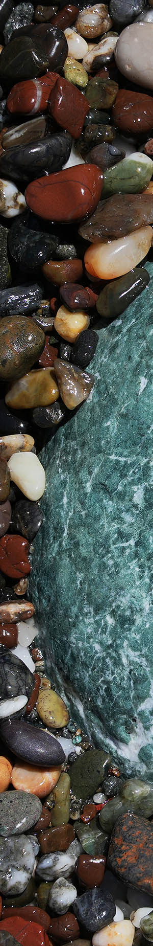
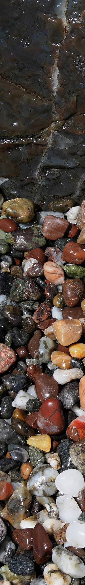
VP08497-19h 5800x3700 pixels 1 frame 22 shot focus stack blend a6700 56mm
enlarged vertical slice view
On this beach, were minor areas of exposed surf smoothed, wet mélange beach stones, though the best piles were higher on the tide level, already dry, unworthy of bothering with. What was available turned out to be productive as I worked another 9 subjects. The first above at 12:50pm, were stones around the top of a nearly buried, beautiful cyan hued boulder. Green to bluish iron bearing minerals formed in reducing anoxic, low oxygen tectonic subduction zone environments that were likely deep water marine or swampy areas. When oxygen is present iron rusts to orange hues. Tides this afternoon were rather static, so the waves kept refreshing features every few minutes. I shot this subject twice with the better second effort unusable due to not setting the near Focus Bracket point correctly, resulting in a soft bottom left corner foreground. The above right small crop shows what these images look like at 100% pixels detail.
There are 3 states in which to photograph such stones, dry, wet with sunshine, or wet with overcast. With sun at a mid day altitude, a more aesthetically saturated wet stone surface results but which adds bright reflective specular highlights. The smaller a lens aperture used, the greater Zerene Stacker automated Align and Stack (Pmax) mode creates larger artifact circles around such bright specular elements. That also results in bracket sequences continuing to shoot till whatever maximum shot sequence setting is reached that in my case is 50 images, because the software interprets those highlights as sharp even if all else is out of focus. I used F5.0 this day, that though sharper than say F8.0, caused larger out of focus specular artifacts. During post processing, I delete all shots beyond those with in focus elements.
The better stone photography is usually mid day when sun more directly shines downward between stones than when at a low altitude that creates more shadows. With traditional single shot photography in order to have adequate depth of field, one positions a lens directly above subjects so all frame points are at similar equidistant distances. With focus bracketing, one can position a lens at any inclined angles that more easily allows keeping camera on tripod shadows away from subject frame areas as well as often providing better frame element geometry. I never touch, move, or add elements to any stone close-up subjects that reflects my like work with close-up flower and landscape subjects.

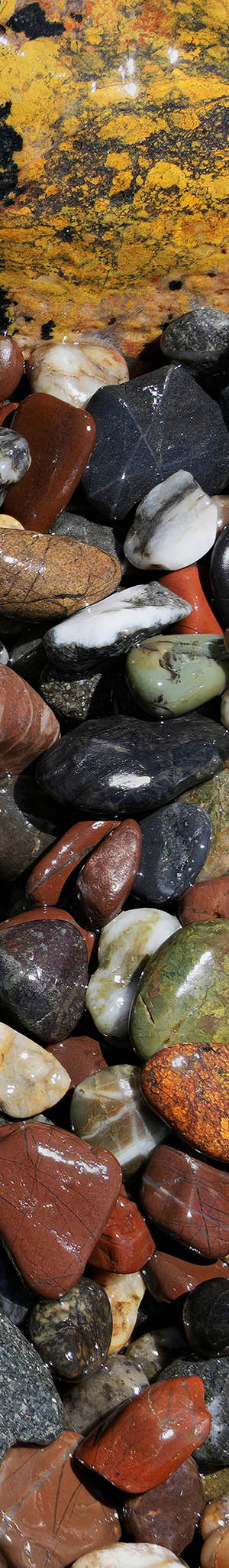
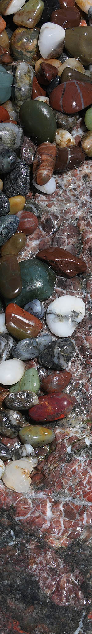
VP08547-68h 6150x4100 pixels 1 frame 22 shot focus stack blend a6700 56mm
enlarged vertical slice view
At 12:54pm worked these wet surf smoothed mélange beach stones up against a bright yellow with black hued boulder. The larger light red stone just below the yellow rock midframe, has considerable unaesthetic specular highlights as its surface began to dry.
At page top at 12:59pm are stones laying atop a nearly buried, translucent, light cyan green boulder of chalcedony chert, the surf had just seconds before washed over. I had then quickly placed my tripod down and cranked off a set of shots.

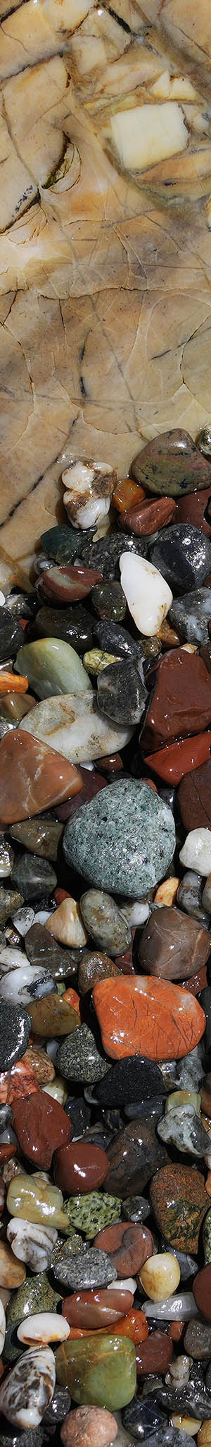
VP08697-15h 5500x4100 pixels 1 frame 19 shot focus stack blend a6700 56mm
enlarged vertical slice view
Next above at 1:29pm shows wet stones like precious gem jewels, up against a wet, light tan pastel hued boulder.

VP08747-80h 6100x4100 pixels 1 frame 34 shot focus stack blend a6700 56mm
enlarged vertical slice view
At 1:33pm, finally was able to capture the above that I'd been regularly looking at for most of an hour. It was low enough in the tide level that I kept being chased away as waves rolled in during attempts to tripod near it. The mix of stones kept changing, as it was in the path of a draining through sand stream. Amazingly at one point per above image, managed to tripod quickly and then get off a set of focus bracket shots. The orange light green rock was often totally unburied. In the upper left frame corner is a small pooling area of water atop some stones with a line of bubbles up against the darker gray serpentine purple rock with yellow-green, red, and white bands. Notice how none of the underwater stones have specular highlights. In all these rock, white veins are usually silicon dioxide that is quartz. Left of the orange light green rock is a white with blue piece of mussel shell. Some of the white "stones" are also pieces of white shells.

VP08847-69h 6150x4100 pixels 1 frame 28 shot focus stack blend a6700 56mm
enlarged vertical slice view
Above is another subject of stones up against a larger partially buried boulder with an interesting mix of deep cyan blue and dark brown hues.

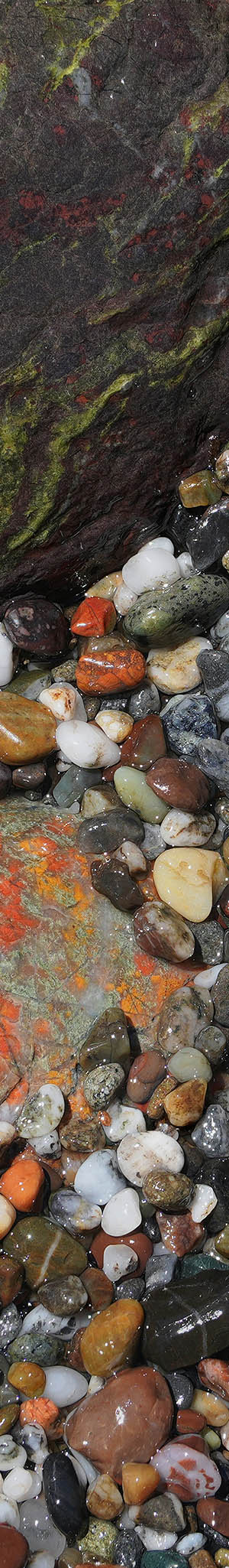
VP08897-24h 6150x4100 pixels 1 frame 23 shot focus stack blend a6700 56mm
enlarged vertical slice view
My last subject this day at 1:54pm and also my favorite of the day, is the above image of a particularly excellent group of supporting wet stones above a nearly buried, incredible looking mélange chert boulder with red, black, and white hues. The below image, to show actual detail in these wet stone images, are small crops at 67% full pixels of individual stones within the above VP08897-24h.jpg image. Note the chert agate, a bit left of frame center. To its right is maybe another chert agate with interesting yellow color and just above right some classic bright red chert jasper. Also note, a frame edge right, someone's partially eaten caramel candy.

At 2pm, I began fighting my way up to the top of the bluff using my big tripod for support. Well, I removed my camera from the tripod and placed it safely into the daypack. Then at the top of the bluff was more effort to push through dense low height brushy vegetation to reach a trail. Within a short time was driving south towards Bodega Bay, then Petaluma, US101 over the Golden Gate Bridge, San Francisco, I280. So by 4pm, had reached home on a rather long day, much more wearying than expected.
NEXT: Page 9 Sonoma Coast State Beach 5/20
2026 Trip Chronicles: Contents