
UQ04772-04796-2x1v 6600x6100 pixels 2 frame 2 column 1 row 25 shot focus stack stitch blend a6700 30mm
enlarged vertical slice view image text section
NEXT: Page 10 George Lake Backpack 8/5
2024 Trip Chronicles: Contents
Green Creek Backpack 7/24
Green Creek Backpack 7/25
Green Creek Backpack 7/26
Green Creek Backpack 7/27
Green Creek Backpack 7/28
After my Gilmore Lake backpack, on recreation dot gov, I reserved a 5 day wilderness permit for two of us into the Green Creek area of Hoover Wilderness. Four days later, I also reserved two permits into the John Muir Wilderness to George Lake on August 5 and 5 days to Treasure and Long Lakes on August 8. The next major activity was the Rolling Stones concert at Levi Stadium on July 17 where to of us had field level standing room tickets, that went well. The following week I prepared and then packed up gear.
caltopo Green Creek online map
On Tuesday July 23, bro J and I linked up at bro S's residence in Tracy, where he left his truck as I then drove we two towards our Green Creek tailhead via SR108 over Sonora Pass. A Mexican monsoon event in the Sierra Nevada was forecast to end Wednesday. Strong thunderstorms occurred Tuesday that dissipated by time we reached Bridgeport at dusk. From US395, the Green Creek washboarded dirt and gravel road is another 9 miles. That usually horribly dusty road was nicely not so given storms. As we reached lower Green Creek areas, I was continually dodging California toads, Anaxyrus boreas halophilus, that given the rains were looking for mates. Arriving at paved parking lot at 8020 feet that had maybe 20 vehicles, we tossed our sleeping bags down where I was surprised to actually get a pretty good night's sleep.
With dawn rising on a sunny Wednesday July 24, 2024, we didn't waste time getting up and finishing packing up gear. This 75 year old person that weighs 138 pounds would be carrying maybe 55 pounds that included 2.6 pounds of Bose speakers and 1.9 pounds of fishing gear, that I normally don't carry. Unfortunately for this web page, after the trip, I have not been able to locate the SDcard media used in my Canon ELPH190 compact digital camera that included a range of usual informal shots like images of our camp sites and cooking. J immediately had trouble breaking two pack straps on his Osprey backpack including the waist belt strap, so had to cluge up fixes.
A short ways up the trail, I stashed my moto g smartphone inside a Ziplock bag. The first 6/10 mile is an inefficient foot path parallel to a cabin dirt road along the creek, that then joins another dirt road for 3/10 mile with another 3/10 mile of level trail, before the route begins climbing at 1.3 miles. With much water on landscapes and vegetation from the previous day's rain being evaporated by the sunny morning rays, our trail despite moderate temperatures was quickly rather humid causing us to sweat. As usual, I stopped to briefly sit on many available logs and boulders.
Slowly by mid morning, we reached our first longer break objective 2 miles in at 8850 feet, up 900 feet, at an avalanche zone clear of trees. Exploring a short ways from the trail to that section of the West Fork of Green Creek was a disaster as areas near the stream were covered by avalanche logs and willow thickets making access difficult. We left about 45 minutes later and soon reached the stream below heavily used Green Lake at 8950 where J scouted areas below we might camp at on our last night. By that time of late morning, cumulus clouds were forming indicating per forecast, storms were likely. It was also quite windy. We had another 600 feet of vertical to reach the East Lake outlet where given storms, we made a change of plans to camp at the south end of the lake.
When we eventually reached East Lake, storms were bearing down. We set up camp a bit above the trail near the outlet in a tall dense lodgepole pine forest, that was an excellent lightning safe and wind blocking location to endure storms. We had just enough time to make dinner and jump into the chilly lake. Rain arrived by mid afternoon that kept us in our tents for 3 hours before skies began clearing. Afterward, I explored the area up to the ridgeline. High winds actually increased in the evening and continued well till midday Thursday.
With dawn rising on a mostly sunny windy Thursday July 25, 2024, I was uncertain about the weather that was obviously not following the forecast. Thus we would stay put for awhile. J with fishing gear and I set out to the northwest end of the lake where he caught a few brook trout. By late morning though still quite windy, clouds moving rapidly from the west meant storms were unlikely. So we packed up with the cleaned fish and continued along the trail along the east shore and then at Nutter Lake went off trail to locate our base camp for the following 2 nights. This day's effort was only about 200 feet of vertical and one mile.
On our last visit to small Nutter Lake about September 2010, we caught a few larger size rainbow trout but it appeared the lake was now barren. I wanted a base camp well away from trails, near water sources, and out of the strong winds. At a fine location I made note of pre-trip via Google Earth, we chose a spot within dense lodgepole pine that took care of the still gusty downdrafts. J and I walked down to Nutter Lake for a cleansing quick dip. He pan bake fried his trout while I made Minute rice we mixed in. A most enjoyable afternoon meal.

UQ04411-47 6150x4100 pixels 1 frame 37 shot focus stack blend a6700 56mm
enlarged vertical slice view
By 4:30pm PDT we were out exploring our zone that included some rusty orange glacially smooth metavolcanic bedrock knobs. That rock per above had fascinating surface features of leached out mineralization as varnish and solution pits. Thus worked the first image subject of the trip. Most of my close-up work uses the sharp frame edge to edge Sigma 56mm DC DN F1.4 prime lens.
My Sony a6700 in its valuable focus bracket mode, cranked out 46 shots at F5.0 at a slightly downward angle with the last 10 beyond furthest in focus elements I deleted later during post processing leaving 37 useful shots. Focus bracketing makes such subjects much less work, dramatically reducing the number of shots versus done manually since I no longer need to guess minimum distances between shots required for maximum resolution. However, the camera often takes more shots than necessary that is preferred to stopping early, so I check for then delete those shots later during post processing. I set the limit at 50 shots that is rarely reached. A lens only sharp at frame center as many zoom lenses are, even if refocused on edge elements, may result in noticeably soft image areas.

UQ04473-81 4100x6100 pixels 1 frame 9 shot focus stack blend a6700 30mm
enlarged vertical slice view
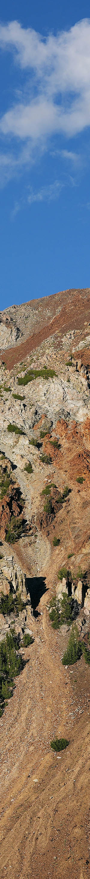
By 5:30pm I had located the best nearby location without blocking pines to shoot rusty red metamorphic sedimentary 12374 foot Dunderberg Peak, the main subject for late afternoons. There, I worked the above single frame landscape requiring 9 focus bracket shots. The peak has the same geology as the East Lake area while the colorful peaks and canyon further west are extrusive igneous rock.
With the Sigma 30mm, 56mm, and Sony 85 primes, I primarily use the F4.0, F4.5, and F5.0 highest resolution apertures per lens testing test sites. Since all my work is tripod mounted, I also use highest resolution low ISO 100 or ISO 200. For distant subjects without any near frame elements at the F5.0 aperture, I don't use Focus Bracket, Drive Mode and instead use the Single Shooting, Drive Mode. Because I use an RF Bluetooth shutter release, Pholsy RMT-P1BTA, I don't have vibration issues from manual shutter activation.

UQ04484-04497-2x1h 9700x4000 pixels 2 frame 2 columns 1 row 14 shot focus stack stitch blend a6700 30mm
enlarged vertical slice view
This next subject above worked at 6:51pm after shadows had enveloped our camp zone, shows Dunderberg Peak and its southwest ridge separating Green Creek from the Virgina Creek headwaters basin. Because of sensor latitude limitations, those shadow areas render near black while someone standing there would see plenty of dim shadow features, a reality of photography versus human eyes that even minor exposure bracketing won't fix.


The above is a 2 frame horizontal 30mm stitch blend that is much easier now with the a6700 due to its Electronic Level function I tend to use on all shots. The display needs to be set for Rule of Thirds Grid display mode. My tripod Nodal Ninja III MK II manual panoramic head for stitching, only has detents and leveling for vertical mounted lens orientations. For horizontal lens mounted positions like the above, a tripod without the Electronic Level function is difficult to accurately adjust gravity level and is also less vibration stable. For vertical lens orientations, my two stacked tripod heads have less accurate spirit levels tools though now bring balance close that then just requires minor tweaks. With the Electronic Level function in lens horizontal orientations, moving from one stitch position to the next is faster and much more accurate.
For manually stitch blending frames, there should be at least an approximate 1/3 overlap between frames. Thus, I use the Rule of Thirds Grid display mode. One should set up the first image in a set horizontally balanced using the Electronic Level so green replaces any orange tilt. For a second frame, any one of the green dots at frame edges I added to the display image, need to be moved to corresponding red dots on same grid lines while also balancing the horizontal level for that same red dot point. The vertical level can be ignored as long as one of the red dots on grid lines is used. That will result in a 1/3 overlap. From the 4 green dot positions, I choose one that has some subject element I can easily recall the exact position of once moving a head position. Losing the exact position, may result in having repeat shooting all frames again.

UQ04512-04521-1x2h 6100x5800 pixels 1 frame 10 shot focus stack blend a6700 56mm
enlarged vertical slice view
The last Thursday image above of Dunderberg Peak using my 56mm lens showing the unconformity geology transition between igneous granite and sedimentary metamorphic. With the wind still gusty and a full day ahead, I declined waiting around till sunset as both of us retired to our tents. During the night, the wind finally lowered some though was still breezy by sunrise. With towering Dunderberg Peak to the east, sunlight would require an hour to rise up enough to illuminate peaks west of East Lake and its waters.

UQ04522-04540-4x1vb 9700x4000 pixels 4 frame 4 columns 1 row 19 shot focus stack stitch blend a6700 30mm
enlarged vertical slice view
We left our tents after sunrise Friday July 26, 2024 after sunshine moved down Page Peaks and Gabbro Peak. Thus I had plenty of time to set up my camera before at 7:14am working this first subject of the day above, a 30mm lens 11,300 by 6100 pixel 4 column stitch blend. I included little of the East Lake waters because of shadows lower left. One will note the still warm light on the rock. The deep greenish brown lake water itself reflects that same geology. Only in the afternoon when shooting northward does one capture blue waters. The cliff band along the west lake shore prevents any circumnavigation around the lake. Ideally aesthetically, would be an uncommon calm morning offering far shore landscape reflections.

UQ04541-04587-2x2v 6800x9200 pixels 4 frame 2 columns 2 rows 47 shot focus stack stitch blend a6700 30mm
enlarged vertical slice view
With sunshine finally reaching my position at 7:30am, with my 30mm lens worked the above 2 column 2 row stitch blend with a foreground of the glacially smooth lichen covered rusty dome plus a small whitebark pine.
Although for such a tall vertical subject, I might have used my Sony SEL1650 pancake or Sigma 19mm lenses, both those lenses are soft away from lens frame centers. Any combined vertical row plus horizontal column frame subjects are more difficult for stitching software because warping used to fine adjust overlap sections may make adjacent frames less element compatible preventing running.

UQ04611-04630-1x2h 6100x6500 pixels 2 frame 1 columns 2 rows 30 shot focus stack stitch blend a6700 30mm
enlarged vertical slice view
I hiked further east to the trail then at 8:03am worked this mediocre Nutter Lake reflection of 10.9k Page Peaks between breezier periods. We never saw any trout rise to its surface.

UQ04637-04694-4x2v 15500x9000 pixels 8 frame 4 columns 2 rows 58 shot focus stack stitch blend a6700 30mm
enlarged vertical slice view
At 8:20am, I reached the trail overlook point at the southeast end of East Lake then set up the above 4 column 2 row 8 frame stitch image requiring 58 shots. Notice how an hour later, rock has less warm coloration versus UQ04522-04540-4x1vb. Epidote Peak is at left and Page Peaks at right. Between them is the light orange hued ridge leading to out of view Camiaca peak. Another East Lake subject that would be best on an uncommon calm morning.
During post processing, using Photoshop CS6, I was unable to stitch the 8 frames without resulting artifacts although I tried combining frames in various ways. A few months earlier, my old HP desktop running Windows Vista on which I ran Kolor Autopano died. Kolor closed their company in September 2018, so there was no way for me to move that stitching application onto my Dell Windows 10 laptop. CS6 usually does ok with small stitching jobs but often cannot finish more complex frame sets without artifacts and weird warping. Fortunately, I recently discovered Kolor left a version of its newer application, Autopano Giga 4.4, with a similar interface available for customers including a License Key code.
After installing that tool, all my stitching using Planar mode has gone smoothly. On subjects like this using wider lenses, frames at left and right edges warp larger versus those at center resulting in bat wing shaped outputs that upon cropping to rectangles will clip off those ends. Thus anything important in a frame at those top or bottom left and right edges requires using a wider capture lest they become cropped away. Because all stitching software needs to work from slightly expanded file sizes, for the sake of not reducing apparent resolution, one should also reduce output dimensions to no larger than sensor dimensions that for the 26 megapixel a6700 is 6192 by 4120 pixels.

UQ04713-04760-4x1v 9600x6100 pixels 4 frame 4 columns 1 row 48 shot focus stack stitch blend a6700 30mm
enlarged vertical slice view
The next subject on this morning's planned agenda would be at Gilman Lake about a half mile away. There is a well-worn use path vectoring off the main trail not far from the southeast end of Nutter Lake that leads to campsites at a stream section 500 feet below the lake outlet. From there at a log jam crossing, use paths end with travel about the east shore awkward over uneven metasedimentary rock. I explored those areas and settled on the above 30mm lens 4 column stitch subject with a colorful rock and lichen foreground. In the foreground frame right is a wind stunted mountain hemlock.
At page top is my strongest image of the trip worked at 9:10am from the east Gilman Lake bay where a dense patch of soft arnica, Arnica mollis, provided a superb foreground. Mixed in were a few blooming western aster, Aster ascendens, and swamp onion, Alium validum. Fronting the lake shore are the ubiquetous Sierra willow, Salix orestera, with mountain hemlock, lodgepole pine, whitebark pine, along the shores. I also worked a flowery stream area, however the still strong breezes made the result difficult to process due to misregistration between focus bracket shots.

UQ04829-04840-2x1v 7000x6150 pixels 2 frame 2 columns 1 row 12 shot focus stack stitch blend a6700 30mm
enlarged vertical slice view
After leaving Gilman Lake, at 10:28am worked this no name pond southeast of Nutter Lake with Page Peaks in the background that J also took a dip in.
At mid day, we carefully climbed down 200 dangerously steep feet to the south end of the lake. There is no use trail. At the lake, Joe immediately began landing fair size eastern brook trout. I grabbed his rod and caught one myself that has been hanging out under a shady ledge of deep water just below us. Enough trout to fill his 11 inch frying pan making for another fine trout and rice meal.

UQ04908-04915-2x1h 8900x4000 pixels 2 frame 2 columns 1 row 8 shot focus stack stitch blend a6700 30mm
enlarged vertical slice view
At 4pm I hiked out to an East Lake overlook with a view northward across the length of the lake towards Monument Ridge. Note the windy downdrafts on those waters.

UQ04960-72 4100x5600 pixels 1 frame 13 shot focus stack blend a6700 56mm
enlarged vertical slice view
56mm lens close-up of plant growing in crack of a vertical rock wall of glacially smoothed schist.

UQ05047-05068-1x2h 5900x5400 pixels 2 frame 1 column 2 rows 22 shot focus stack stitch blend a6700 30mm
enlarged vertical slice view
At 5:43pm, a view of above image noted rock wall with noted plant lower left. Dunderberg Peak in background. Was a difficult subject due to cloud shadows I finally aborted from. The glacially smooth whitish gray bedrock at frame lower right was a fine grain metasedimentary schist. Our camp was just left in those hemlock.

UQ05069-84 6000x4000 pixels 1 frame 16 shot focus stack blend a6700 30mm
enlarged vertical slice view
As dawn rose on Saturday July 27, 2024, the breezy conditions were not going to offer anything worthwhile I had not already captured, so we packed up and began hiking out. By 8:14am, at a crossing of the East Lake branch of the West Fork of Green Creek, we reached a dense with wildflowers stream area where after capturing a 1080p short video, used focus bracketing to capture this still image. Unfortunately, even down in this deep forest, a breeze though light, was strong enough that is made plant elements move causing unworkable misregistrations between shots. I was lucky to get just enough of a breeze null so the above mediocre image didn't require much post processing work. Lewis's monkeyflower, Mimulus lewisii, monkshood, Aconitum columbianum, ranger buttons, Sphenosciadium capitellatum, arrow-leaf scenecio, Senecio triangularis, silver lupine, Lupinus argenteus, crimson columbine, Aquilegia formosa.

UQ05136-49 6000x4000 pixels 1 frame 14 shot focus stack blend a6700 30mm
enlarged vertical slice view
Also worked this above single frame subject that shows how lushly green such gardens are. By late morning we had reached Green Lake and made campsites a bit downstream from the lake, well away from a few dozen others camped along the east end of the lake severely beaten up heavily used camp sites. We spent the rest of that afternoon relaxing, eating remaining pack food, exploring our creek and lake areas, and J even fishing a bit. I did find a good camp site on the less used north side of the lake I may use in the future.

UQ05249-05271-3x1v 9750x6100 pixels 3 frame 3 columns 1 row 23 shot focus stack stitch blend a6700 30mm
enlarged vertical slice view
On our fifth and last day of the trip, Sunday July 28, 2024, I was up early to take down my tent and pack up gear. Then set out to the far east end of the lake where I worked the above mediocre subject, the last of this trip. Green Lake, and no name metamorphic geology peaks along the north side of Glines Canyon. The stream at frame right is from West Lake.
NEXT: Page 10 George Lake Backpack 8/5
2024 Trip Chronicles: Contents