
VK00071-00085-2x1v 6500x6100 pixels 2 frame 2 column 1 row 15 shot focus stack stitch blend a6700 17-40mm @19.7mm
enlarged vertical slice view image text section
NEXT: Page 4 Antelope Valley 3/17
2026 Trip Chronicles: Contents
Carrizo Plain National Monument 3/13
Antelope Valley 3/13
Antelope Valley 3/14

VK09996-00017-3x1v 8000x5200 pixels 3 frame 3 column 1 row 21 shot focus stack stitch blend a6700 17-40mm @40mm
enlarged vertical slice view
At sunrise of Friday February 13, 2026, I packed up gear, then drove off from my 2 night camp. After a couple brief stops to look around along my way, I drove out on Simmler Road to the mid point of Old Potato Lake. Given it was early with the night breeze still active, I didn't need to immediately hike to the prime area I had left Wednesday. So after grabbing gear, set out due east to the lake to the edge of the shore bluff where I noticed eleven American avocet, recurvirostra americana, standing in shore shallows a bit north where a small ravine put sediments into the lake forming a bulge in the shoreline. Some birds were feeding, sticking their long curved beaks into the alkali mud just below the surface where small crustaceans and brine fly pupae thrive. Three birds were resting on one leg. The alkali mud is so soft, even coyotes won't venture out onto the otherwise free of footprint other than bird's shores.
So continued to a location where I could frame the birds, a slightly wavy lake reflection, and the Temblor Range. As I approached the birds, I could tell they were becoming anxious, so moved slowly, not looking in their direction further back from the bluff above the lake. Then while they were watching, slowly inched closer to an overlook of a small ravine as they continued feeding more calmly. At 7:43am fired off 3 sets totaling 17 shots. Then slowly moved back from the bluff out of their sight to continue towards the northwest end of the lake. Hillside daisy yellows are on the distant shores with saltbush. A twelfth smaller bird with a light belly, is visible in the vegetation on the enlarged vertical slice view just below the avocet at left. Near the left frame edge is a more orangish yellow section of California goldfields, with all the rest to frame left bottom corner alkali goldfields.

VK00018-00044-2x1v 9900x4000 pixels 2 frame 2 column 1 row 27 shot focus stack stitch blend a6700 17-40mm @40mm
enlarged vertical slice view
Moving further, at 8:03am I stopped to work an image showing the somewhat dry, rounded corner of the lake with Bigelow's coreopsis, alkali goldfields, California goldfields, filaree, fiddleneck, and saltbush. It appears this area like the Temblor Range in the background, received less precipitation than the south side of the lake with little from the mid February storms. This subject was actually shot as 3 verticle columns, however the right column infinity focus was soft as the camera apparently ended its sequence early.
Rounding the northeast corner of the lake at page top at 8:17am, with the Sigma 17mm-40mm zoom at 40mm, worked at page top this nice 19.7mm image with terrific clouds across the full 1.25 mile length of Old Potato Lake. Less aesthetic, all the coreopsis were brown and drying probably blooming after the New Years storms, amid ugly cheat grass. Although I would not be capturing any truly calm mirror reflections in the lake this morning, the lake was near calm enough and the sky full of hazy high clouds, to create some nice images.

VK00134-42h 6150x4100 pixels 1 frame 9 shot focus stack blend a6700 17-40mm @40mm
enlarged vertical slice view
Given this north end of the lake was less aesthetically dry, I then rapidly rambled through much shin to thigh high vegetation a mile south to the lusher southwest end of the lake I had visited on Wednesday. At 9:10am, stopped to work this above subject with more recently risen bright Bigelow's coreopsis, and Lemmon's mustard, Caulanthus anceps, that tend to grow in small patches within the coreopsis. Because they tend to very easily move in even a slight breeze, I backed away some using a dense patch of filaree for the foreground, while only gambling with a single horizontal frame, then lucked out with a momentary lull.

VK00143-00171-3x1v 9100x6100 pixels 1 frame 19 shot focus stack stitch blend a6700 17-40mm @40mm
enlarged vertical slice view
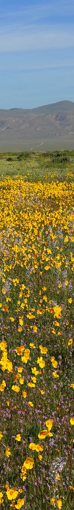
By 9:20am, I was fully around the southwest end of the lake where with the zoom at 30.9mm, set up this 3 column stitch blend north northeastward across a fine patch of fresh blooming California goldfields, purple owl's clover, tidy tips, recurved larkspur, filaree, fiddleneck, and saltbush. The dried branches at frame mid center next to a tall clump of cheat grass is a dried alien Russian thistle skeleton that tend to get stuck on saltbush clumps. Saltbush tend to be denser around perimeters of the alkali ponds because their taproots reach down to great depths at the same water levels as these ponds.

VK00197-00228-2x1v 6300x6100 pixels 1 frame 32 shot focus stack stitch blend a6700 17-40mm @30.9mm
enlarged vertical slice view
After working a subject closer to the lake, with too much cheat grass and saltbush that also moved in the still slight breeze, I moved further south where flowers were the best in this zone. At 9:31am worked this area of Bigelow's coreopsis and tidy tips, that were particularly impressive, plus California goldfields, filaree, fiddleneck, purple owl's clover, recurved larkspur, saltbush, with a bit of Old Potato Lake and the distant Temblor Range. Note the jet contrails, that per my long held non-manipulative style, leave as is.

VK00256-00284-2x1v 6000x6100 pixels 1 frame 29 shot focus stack stitch blend a6700 17-40mm @30.9mm
enlarged vertical slice view
Then at 9:39am, pointed the zoom west across a nearby terrific mixed expanse of flowers with the zoom at 25.4mm and the Caliente Range in the distance. In the middle distances were impressively dense pans of tidy tips plus California goldfields and purple owl's clover.

VK00328-00444-3x1v 6800x6000 pixels 2 frame 2 column 1 row 37 shot focus stack stick blend a6700 17-40mm @30.4mm
enlarged vertical slice view
My last subject this productive morning at 10:13am, with purple owl's clover, California goldfields, Bigelow's coreopsis, filaree, recurved larkspur, tidy tips, phacelia, saltbush, and the Temblor Range.

By 11am, I was back at my vehicle After reorganizing gear, drove northwest on dusty Simmler Road to Elkhorn Road, then east on the SR58highway over the Temblor Range pass. On the east side, per above, I was surprised to see significant numbers of roadside areas with California poppies, California goldfields, and more. California poppies are uncommon in the monument. Some of these areas were unfenced and without NO TRESPASSING signs, and no cattle, that meant, even if private lands, one might explore some, as long as one has not been asked to leave. Most trees are California juniper, Juniperus californica, that are more common on the eastern side of the Temblor Range.
However this afternoon, instead of that diversion, I was intent to reach Antelope Valley with still some time to do photography. That turned out to be a quite fortunate choice even after stopping for an hour in Taft at the Albertsons supermarket, for perishable food/drinks, ice, and lunch and also gasoline. Note, Taft, the nearest town with services, gas, and supplies, is via Seven Mile Road and SR58, about a 45 mile drive from the monument's Soda Lake Road northern boundary.
By 3:30pm, I reached the SR138 areas northeast of the state park. Along SR138 to the west, had passed plenty of familiar areas with orange poppy expanses, I then expected I might be exploring the following day, Saturday. Then out on unnamed dirt roads, I reached a truly excellent lush green Antelope Buttes hilly zone, parked, and before going to work, phoned D in Colorado, who had been considering driving out, with an update to conditions. To better understand where these below landscapes are, below is an enhanced caltopo dot com USGS topo map with a few added magenta text numbers.

Below is a Google Earth satellite images from January 20, 2023 that best shows the maze of all unsigned, mostly unnamed dirt roads, in the Antelope Buttes zone and also trails of the state poppy reserve. Many of those roads can be driven carefully with just 2WD while others are 4WD only in spots. I overnighted at 4, beside the northeast end of Fairmont Butte. 1, 2, and 3 are usual entry points from the SR138 highway.

Below is the Copernicus.eu satellite image on March 10, 2026 that I used to understand where flowers were. The nearby state park had a mediocre bloom despite good rainfall. I suspect that was because its seed bed had been depleted during a recent year when seeds germinated but died due to inadequate root moisture, without producing seeds. I won't be explaining exact locations I worked for the below photos, however, they are within the maze of dirt roads within Avenue D through F by 140th Street through 110th Street. The Ave D through D8 and 120th through 130th Streets had the most orange poppies. The average precipitation for these western Mojave Desert areas is 11.55 inches so this winter, much more had fallen though most occurred from just 3 storm periods with little otherwise.

The last significant rain was on March 31, when 0.19 inches was recorded at the poppy reserve weather station but greater amounts fell nearby that was why some areas had fresh goldfields that rise a week after such late winter storms. Some dirt roads still had water puddles 2 weeks later. The deep green rectangle is farm crops.


VK00443-00513-3x1v 9500x5200 pixels 3 frame 3 column 1 row 70 shot focus stack blend a6700 17-40mm @35.6mm
enlarged vertical slice view
Atmospheric conditions were unexpectedly as ideal as I might ever expect with only a slight intermittent breeze and skies covered with thin hazy clouds providing perfect diffuse landscape lighting. The above is a 3 column stitch blend at 3:39pm with my 17mm-40mm zoom at 35.6mm of purple owl's clover, California goldfields, bicolor lupine, filaree, California poppy, and hills of the Antelope Buttes. Two dirt roads cut across this shallow drainage but are below the vegetation levels from this lower perspective.

VK00514-00553-2x1v 6400x6100 pixels 2 frame 2 column 1 row 40 shot focus stack stick blend a6700 17-40mm @23.9mm
enlarged vertical slice view
A northward at 23.9mm zoom at 3:43pm, with the same species plus creamcups, Platystemon californicus, and the Tehachapi Mountains in the distance. There are many solar farms and high voltage electrical transmission towers in the area that I carefully avoided including in my frames. The goldfields were quite fragrant indicating some had just risen within a day or three.

VK00586-00622-2x1v 6800x6000 pixels 2 frame 2 column 1 row 37 shot focus stack stick blend a6700 17-40mm @30.4mm
enlarged vertical slice view
Another similar northward view at 3:55pm of the flower mix towards the Tehachapi Mountains with a bit much alien cheat grass and gone to seed filaree. After filaree bloom, plants stems and leaves turn an unaesthetic reddish brown.

VK00719-00769-2x1v 6700x6000 pixels 2 frame 2 column 1 row 51 shot focus stack stick blend a6700 17-40mm @40mm
enlarged vertical slice view
With a bit more blue sky poking through at 4:18pm, the above northward view, 2 column stitch blend at 40mm, with more greens, was the perfect color mix for the coming Easter weekend.

VK00770-00812-2x1v 6700x6000 pixels 2 frame 2 column 1 row 43 shot focus stack stick blend a6700 17-40mm @40mm
enlarged vertical slice view
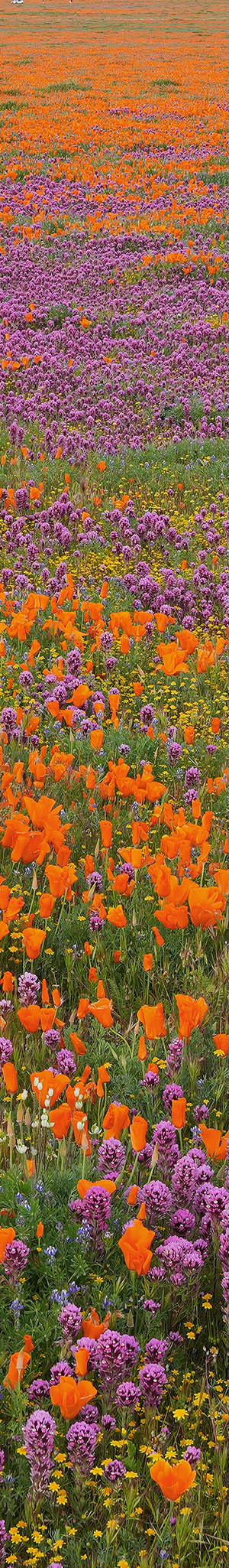
And a southwestward view at 4:09pm at 40mm for a 2 column stitch blend, of dense purple owl's clover in this Antelope Buttes drainage.

VK00813-24h 6150x4100 pixels 1 frame 12 shot focus stack blend a6700 17-40mm @31.3mm
enlarged vertical slice view
I drove off east into the less hilly dirt road maze mostly just looking for what I might work in the morning but at 4:41pm stopped at the above especially lush spot that seemed to be glowing with strong very even saturation in amazing light.
With dusk darkening, to overnight disperse camp inside my 20023 Trailblazer LS, I drove to the dirt road location that I marked as 4 at the northeast end of Fairmont Butte. As the evening progressed, a quite strong loud wind arose. I turned on my Consumer Cellular Pixel 10 PRO mobile data, and found the weather forecast had changed since I left 4 days earlier and a really strong wind event would occur Saturday then not quiet down for days. How disappointing! Fortunately, the few images I had worked this afternoon, that turned out very strong indeed, would have to suffice. I was already mentally commiting to a return as soon as forecasts allowed.
Awake at dawn on Saturday March 14, 2026, I quickly joined other dawn commuters on SR138 as I made my way west then north on I5 over the Grapevine and down into the San Joaquin Valley. Although the 5 hour 320 mile drive was long, I was surprised how by time reaching home at noon, I was still rather little tired. So much so that in the afternoon was out enjoying free live music at a downtown San Jose outdoor venue.
NEXT: Page 4 Antelope Valley 3/17
2026 Trip Chronicles: Contents