
SX00123 5400x3600 pixels 1 frame 1 image A6000 SELP1650@36mm
enlarged vertical slice view image text section
NEXT: Page 6 Rock Creek Backpack
2020 Trip Chronicles: Contents
Sonora Pass
Mono Lake Tioga Pass
Mosquito Flat

After returning home on Saturday, July 25, I was intent on returning as soon as possible on another backpacking trip because, after experiencing conditions the previous week, I was aware that all high-elevation areas of the range I had interest in were already beyond what I considered optimal aesthetic conditions and, with continued dry weather, were becoming less interesting with each passing day. I'd also spent time during my long drive home considering what destination to target, and that was the upper Rock Creek basin that I'd last visited in 2014, the first summer I'd begun using a digital camera for my primary photography versus the 4x5 view camera I'd used for over a decade, and I was aware there was much in that zone I had interest in working. Looking at long-range weather conditions showed that winds would wane.
Recreation dot gov showed a solo opening for Monday, August 3, so on Tuesday, July 28, I secured a permit for Upper Rock Creek. I also had an interest in returning to Sonora Pass for a day or two given what I had seen in passing through Saturday, so I decided I would do a 3-day road trip before starting the Rock Creek backpack. That would also allow some time to be at Mono Lake for dawn one morning and a pre-trip day hike out of Mosquito Flat to shoot the Rock Creek valley from a perspective better reached via a sunrise day hike. Thus I had 3 days to pack up gear and food, which went easily. I would have a bit of time to at least look at my images from the Convict Creek trip and process an image or two.
Thus left early morning on Friday, July 31, 2020, on the same route against commute traffic, across the valley, and into the Sierra on SR108. By mid-afternoon I'd reached Sonora Pass in order to hike out and work areas I'd surveyed the previous Saturday. Weather was sunny and warm, with a usual afternoon breeze from the west. That wind blocked the notion of performing any serious photography work that included wildflower foregrounds, and I thought the following morning would be more productive. So set out on what would be a 3-mile-or-so hike that went beyond where I'd explored the previous week. I found the volcanic landscapes disappointingly already too dry after just a few more days of heat and sun. This view to the right towards the northeast shows there were indeed wildflowers, though in better years there would be lots of big yellow mule ears blooming too.
So instead of spending the night at the pass and working the next morning before driving to Mono Lake, I would continue and park up on Virginia Lakes Road this evening, where I could more easily reach the Old Marina area where I would work at dawn. An additional factor in the decision was that I knew from experience how much better conditions were at peak in the easy-to-reach by car Sonora Pass area after wetter winters, so doing so was better moved into the future. I was surprised to find 2 other vehicles at the Mono Lake overlook location, and then when a third vehicle drove up and parked near where I was, I moved further up the road to a nicely quiet spot at a higher altitude that would also benefit acclimation.
To work early dawn at Old Marina, which is the signed parking area along US395 a mile north of Lee Vining, I needed to get moving in darkness not long after 4am, and that went smoothly. By a bit after 5am Saturday, August 1, 2020, I had pulled into the parking lot with warm light already lighting the far horizon of the eastern sky. One other vehicle with a couple inside was already in the parking lot. I didn't waste time walking the short distance to the shore of the lake where seagulls could be heard noisily squawking and a familiar aroma of the lake was present in the chilly air. I had already set my camera and lens up some ways back from the shore so as to minimize scaring gulls before approaching the area with a good view across the waters reflecting increasingly warm light. It wasn't as calm as on best mornings, though better than average, with no clouds and fairly good dawn colors in the sky.
Shore edges along the lake have hard pumice boulders one can walk on from spot to spot, with bottomless mud between those rocks one must absolutely not step into lest one quickly sink in above one's knee. And then one later would need to deal with trying to clean off the awful, very sticky dark muck, including changing pants. After setting up, I was surprised to see quite a few gulls fly in right in front of my position to feed on the tiny myriad shrimp in the salty alkaline waters. Normally these birds would be skittish if any humans came this close to them along the shore. However, it was still quite dark. I was quiet. I was already set up, moving little to work the camera controls. And these birds were likely used to feeding in this spot early morning without being bothered. Once a few birds did so without looking scared, other gulls flew in for their breakfast too, of tiny brine flies and shrimp that swarm in the quiet edge waters.
My camera strategy was to use the Sony SEL1650 pancake zoom lens without any image stacking because all the birds would render as black shadows regardless. Thus, I would focus maybe 50 feet out on one of the many pumice rocks that help make this area interesting in order to have adequate depth of field. A lack of near-frame sharp focus would not be obvious as that area was darkest. The key was stopping down enough to ensure the distant infinity areas of the mountains out in Nevada were also reasonably in focus. I fired off several shots over a few minutes while aware that, due to the weak light and constant movement of the birds, I could, during post-processing, select ones that turned out well versus trying to view what looked good in the electronic viewfinder. Note I've permanently turned the LCD on the A6000 off and placed black duct tape over that glass to limit glare when looking into the EVF. The reflection image at the top using F5.6 at 39mm of zoom at 5:46am PDT was the best of the set that includes one bird caught flying in the air.

SX00128 5400x3600 pixels 1 frame 1 image A6000 SELP1650@21mm
enlarged vertical slice view
This second wider image above was at 21mm to also capture the arc of dawn color around the axis of the rising sun. Much better than either of these two shots were the two-minute-long 1080p videos I made that show birds feeding and their noisy squawking. However, I have not set up my YouTube video account yet to add videos to my public work, of which I have a few years' worth of videos to someday add. A minute after recording the videos, I made some awkward sound with my camera that spooked a single bird, and as that bird sounded its alarm, the whole group of birds then noisily flew off. But it was already mission accomplished.
As the sun began hitting the high ridge west of the lake, I was making my way back to the Forester. Because of the hot weather forecast, I had decided to spend my day up near Tioga Pass at 9.9k instead of any of these lower areas. Mono Lake is at 6.5k, and the better photography during mornings is in May, when the Sierra Nevada range still has considerable snow and vegetation around the lake is greener. Thus, I drove up SR120 to the park border that had no line of entering cars, though the rangers were already getting ready for what would be a busy Saturday with long lines of vehicles. That was despite the well-publicized and road-signed message at the US395 junction, per pandemic guidelines, that only those who had park reservations for camping or backpacking were supposed to be allowed to even drive through the park. Instead, for practical, considerate reasons, they were giving out dashboard placards for those who did not, who were instructed to not stop anywhere.
I planned to walk in and then walk one mile south, down about 200 feet into Dana Meadows, where there are several shallow tarns along the way, and capture some reflection shots since the air was almost calm. Although many amateurs have an interest in capturing nice reflection photos of mountain scenery, few understand how easy that is at Tioga Pass by doing so in the tarns there. And that is in part because few are ever in the area so early in the morning when conditions are likely calm.

SX00147-00197-4x1v 9600x6000 pixels 4 frame 4 column 1 row 51 image A6000 30mm
enlarged vertical slice view
This first 4-frame panoramic stitch blend image of 12000 by 6000 pixels, with my lens pointed west-northwest, was shot at 7:42 am or over an hour after sunrise, so it wasn't like I needed to be there at sunrise when the meadow is still shadowed by Mt Dana; that would be boring. After arriving at this pond with water grasses, I waited a short while before starting to shoot. The water isn't perfectly still because there are always a few aquatic insects moving about, and a slight cold, damp night breeze flows off Mt Dana's forested slopes onto the meadow before dissipating, though the reflection is rather good. A better scene would be earlier in the summer while the grasses are at peak green and some snow is still showing on the ridge north. Wildflowers on these meadows away from forest edges tend to be sparse.
As noted during my Convict Creek trip, my Sigma 30mm F1.4 DN DC lens had a loose glass lens element causing focus issues, especially in parts of the left frame. At this point, I was still not aware of how bad that was since I had not yet processed any 30mm images shot after the Convict Creek trip. In the above image, that focus issue later, upon post-processing, was evident and resulted in cropping off half of the leftmost frame, removing about 2400 pixels. Overall, the focus is less than optimal, and I would never use this image commercially. That is not of importance, as there are better conditions to shoot during at this easy-to-access location. Had I been aware of the issue, I would have been using an older 30mm F2.8 lens that has a bent outer ring that makes rotating the ring stiff, though the focus is normal across the frame.

SX00198-00258-5x1v 15000x5900 pixels 5 frame 5 column 1 row 61 image A6000 30mm
enlarged vertical slice view
My second reflection is the above 5-frame stitch blend of 15900 by 5900 pixels using my very sharp 60mm lens pointed south-southwest. That is also a good direction to shoot in late afternoon, especially with clouds. The broad mountain at the center is Mammoth Peak at 12106 feet. That is the wide glaciated granite expanse one sees to the southeast of Tuolumne Meadows that, on clear days in early summer at sunset, reflects nice late light in the flooded areas of the meadow. Note that zone within the Dana Fork of the Tuolumne River drainage is a no-backpack camping zone one can only day hike into.
After this, I worked 2 more tarns closer to the pass before returning to my car that, at the time, I knew were of marginal value. Afterwards, I parked down the highway below Tioga Lake and explored some areas to the east that turned out to be of low interest within a dense lodgepole pine forest. I was surprised at all the illegal roadside campers along the shores of this reservoir lake, as INF was obviously taking a low profile given the pandemic, while plenty of inconsiderate groups were quick to take advantage of that. As the day progressed, I set up roadside at one of the few shady spots where I passed time for hours reading, eating, and napping. Late afternoon, I drove out to the South Tufa area and looked at dusk conditions, which, given the minor breezes, were not going to be productive. There were dozens of people in that popular area. In the evening, I drove south on US395 down to the Mosquito Flat trailhead where I would do an early morning day hike.

SX00440-48 6000x4000 pixels 1 frame 9 image focus stack blend A6000 SEL55210@83mm
enlarged vertical slice view
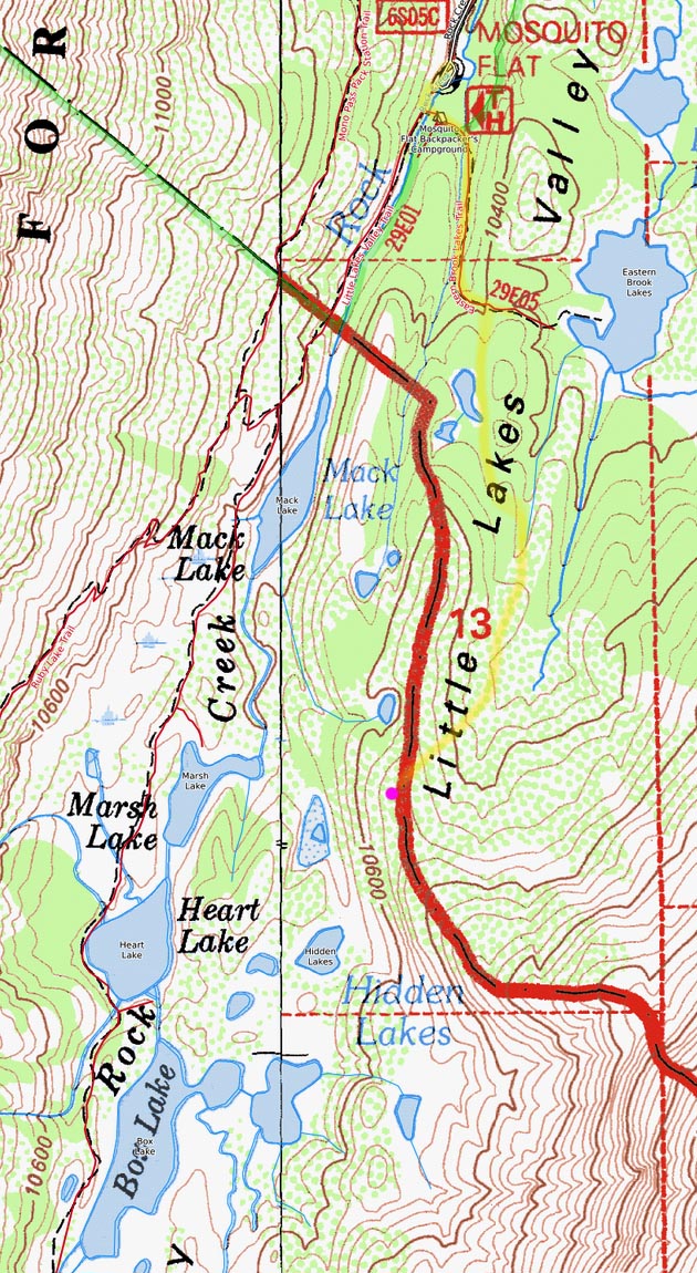
For a few years I had been looking at a perspective up on the east side of Little Lakes Valley to capture some images looking south up the canyon. The nature of the route would be awkward to combine with a backpacking trip route, so I decided to use this extra day to fit that in. At mid-dawn on Sunday, August 2, 2020, I was parked at the Mosquito Flat, which was about half-filled. Just my photo gear and some food weighed less than 15 pounds, including 5.1 pounds of tripod/heads (2.7+1.2+1.1+0.1) plus maybe 7 pounds of clothing/boots (Zamberlan VIOZ GTX 3.3 pounds) for about 20 pounds of total carrying weight. The topo map for the route and area is at the top left on this page.
I set out across Rock Creek through the sleepy campground and up on the Eastern Brook Lakes trail. Upon reaching the forested saddle, I vectored off trail where I passed some ponds and continued on a route south just below the ridge that turned out to be surprisingly smooth, considering it appeared there were no signs of any others doing so. Well, smooth for me, though most trail hikers would find this 1.2-mile, up 500 feet route an obstacle course. At the head of that drainage, I had to drop down a bit and then continued smoothly up the headwall to a rib overlook above the Hidden Lakes. At about 8:20am, I began working some telephotos with my SEL55210 zoom, with this first shot above set at 83mm at F10, aiming at the Ruby Wall, a well-known climber's target that has the most impressive vertical cliffs in the Rock Creek basin. Peak 13188 is mid-left. The lens is not too sharp at the frame edges, as is the case with many such zoom lenses, and a reason I tend to use primes. A reason I later bought the Sony 85mm prime lens.

SX00449-56 6000x4000 pixels 1 frame 8 image focus stack blend A6000 SEL55210@73mm
enlarged vertical slice view
This next target shot at 73mm at F8 shows Mt Dade, Treasure Peak, and 13704-foot Mt Abbott. Photographer friend D and I had once climbed up to a rib to the right of Treasure Peak but found that perspective mediocre.

SX00461-63 5800x3900 pixels 1 frame 3 image focus stack blend A6000 SEL55210@135mm
enlarged vertical slice view
This is 13451-foot Mt Mills shot at 135mm at F8. The class 4 climber's spire in the notch at frame left between Mills and Abbott is known as Petite Griffon.

SX00468-71 6000x4000 pixels 1 frame 4 image focus stack blend A6000 SEL55210@135mm
enlarged vertical slice view
And finally, pointed at the more distant 13720+ foot Bear Creek Spire at the south end of the canyon, zoomed to 149mm at F8. On my subsequent backpack starting the next day, I camped on the broad, rounded dome at frame bottom, which is the Dade Lake plateau.

SX00499-00536-3x2v 9400x8000 pixels 6 frame 3 column 2 row 38 image focus stack stitch blend A6000 60mm
enlarged vertical slice view
Putting on my Sigma 60mm F2.8 DN lens, I worked the above 6-frame, 3-column, 2-row stitch blend of 9400 by 8000 pixels that shows peak 13268, Mt Dade, Treasure Pk, Mt Abbott, and Mt Mills at the skyline and Box Lake below frame right. At lower frame left is one of the Hidden Lakes. The stream entering the grassy area in the back of that lake is the one that flows from Bear Creek Spire below talus into Dade Lake, then below more talus into Gem Lakes, then into Chickenfoot Lake. That then flows into the bay between the two lakes. I once saw a black bear swimming across the grassy channel where it narrows. Otherwise, the stream one sees along the main trail at Long Lake flows from Treasure Lakes and Mt Dade areas.
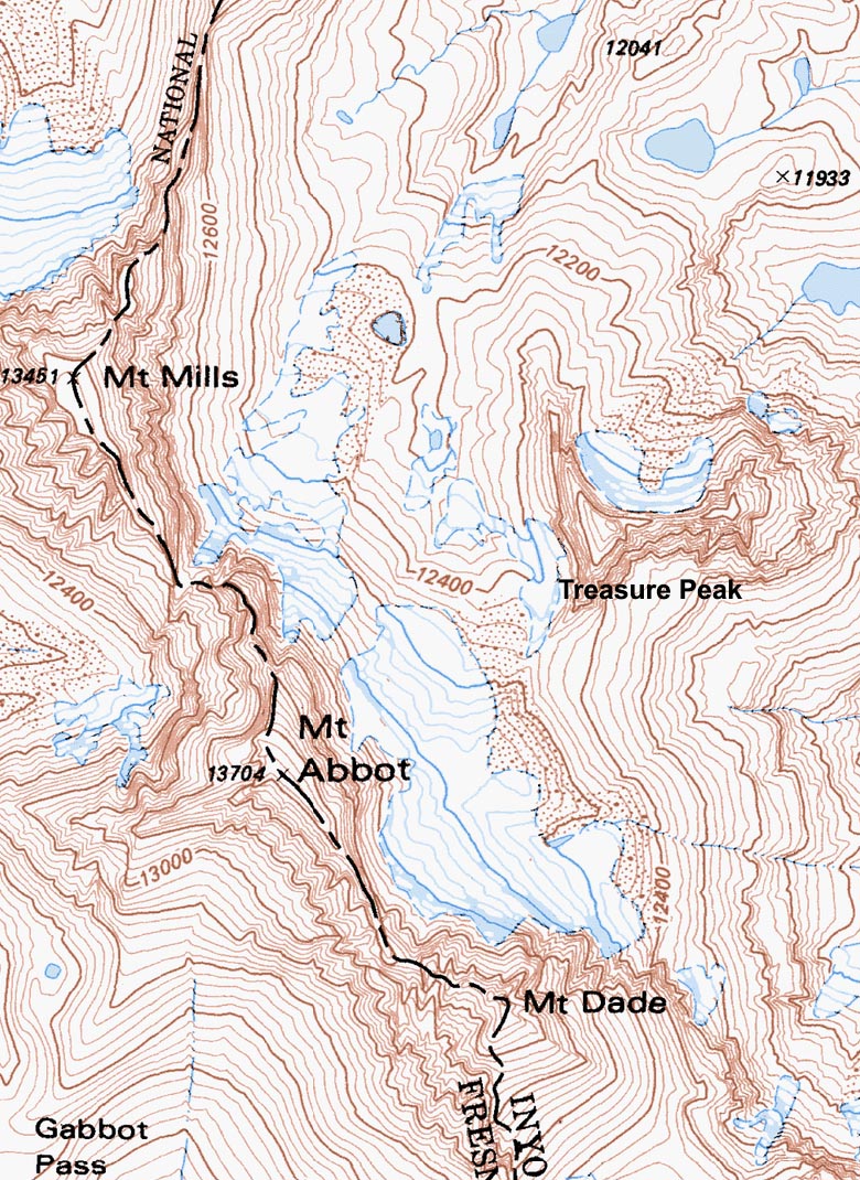
The USGS topographic map for the crest peaks is at page right; some of the most impressive Sierra Crest peaks in the Sierra Nevada Range that are adorned with small glaciers and snowfields. The main trail up the valley routes atop the rock bluff on the far side of Box Lake and is a favorite location most day hikers stop at. However, at 8:30am on this Sunday morning, there was no one there, as few day hikers start hiking trails during early mornings. That is ironic because that is the most beautiful time of day. Rock Creek Canyon has several large campgrounds, with most car camping visitors probably barely out of their tents making breakfast. By 10am, cars start filling the trailhead parking lot, and by noon one sees most on the trail that continues all afternoon. The same is true for many other places, of course, including our national parks. Those few that do tend to be on trails earlier are either fishermen, climbers, or backpackers, though most of the latter also tend to start late morning so they can sweat more.
Before leaving, I also took some wider-angle shots with my faulty 30mm that won't see daylight. A reason I may return some time in early July when there is more snow on the peaks. Because it is right on the wilderness border, one could also backpack in on a late afternoon during clear-air weather so that the next morning's sunrise would provide some nice telephoto views towards the crest peaks. To leave, I monkeyed down a steep class 2 chute with whitebarks to one of the Hidden Lakes and then spent a few hours without taking any more photos exploring some areas of the Chickenfoot Creek branch before heading back to my car.
The rest of the afternoon was spent hanging out at the 10,210-foot elevation trailhead, as it was another hot day lower, and as someone with a wilderness permit for the following day, I would be able to use the backpacker's campground across the bridge. That evening, I methodically emptied all my gear beside the Forester and carefully packed up all of it, as I planned to get on the trail at dawn on Monday in order to reach the Gem Lakes zone early enough to do some photography. The image below, north-northeastward, shows Eastern Brook Lakes in the frame mid-right, with the hot valley at 6k elevation to the east in some usual Owens Valley haze far below.
The 3 days on this road trip segment did produce a few moderately aesthetic results; however, any of those images would be improved under better conditions, so I consider them to be of only modest value.

NEXT: Page 6 Rock Creek Backpack
2020 Trip Chronicles: Contents


