
SZ02518-27 6000x4000 pixels 1 frame 10 image focus stack blend A6000 60mm
enlarged vertical slice view image text section
NEXT: Page 8 Santa Clara Valley
2020 Trip Chronicles: Contents
Robinson Creek 10/15
Robinson Creek 10/16
Robinson Creek 10/17
Conway Summit and Leavitt Creek 10/18
After my Rock Creek backpack, I didn't expect to do any more backpacking this droughty year, however was hoping to do a fishing oriented road trip with bro who had been too busy with business servicing customers during the pandemic summer. A window occurred mid October where work paused due to lack of available replacement materials, so at short notice we made plans. Complicating where to visit were regional pandemic and fire restrictions I carefully distilled understandable policy from. Inyo National Forest was beyond no campfires, not even allowing portable gas stoves except at the few public campgrounds still open while the Bishop BLM region had a total ban on campfires or use of portable gas stoves. Outside of at town parks and in motels, that leaves the gray area of large RVs with internal kitchens as everyone else cannot cook except those that habitually ignore societal rules which there seems to be increasing numbers of.
Toiyable National Forest was still allowing portable gas stove use given a campfire permit which we had. Thus an easy decision to visit the Robinson Creek, Twin Lakes area. As for the restriction policies, this person thinks it is a reasonable response to a small percentage of the public that regularly ignores safe fire policy. In recent decades both about the dispersed front country and backcountry wilderness areas, I see this in increasing numbers of illegal fire pits. The solution then is to discourage visitation for all giving law breakers no others to blend in with hiding behind.

I had low interest this droughty summer for coming fall leaf photography because have learned over decades, larger aspen grove landscapes then tend to be overall mediocre and this has been possibly the driest Sierra Nevada summer in my lifetime after a relatively dry and odd winter. However even during driest conditions, there are some ignored local stream areas where more intimate and close-up leaf work is worthwhile. In fact image, aesthetic of close subjects where leaf texture and detail is visible tends to be more aesthetic than those shot far away where leaves tend to be just small blobs or areas of color. Generally Eastern Sierra quaking aspen groves on open canyon slopes that absorb still seeping snowmelt or monsoonal summer thunderstorms water flowing beneath shallow soils and rock atop monolithic glacial bedrock suffer while those along permanent streams and seeps are not as affected. Thus mid morning on Thursday October 15, 2020 with a warm dry day with offshore winds forecast over Northern California, I drove off out east across the Central Valley, making a pit stop in Sonora with temperatures near 90F for gas and perishable drinks before continuing on SR108 across the range and down to US395. At Sonora Pass at 9650 feet, the temperature was 69F, while east of the pass given a northeast Great Basin flow, temperatures were lower and just 62F at the US395 junction. Along that route aspen conditions were indeed dry looking except along Leavitt Creek at about 8k where that stream flows through a shady heavily forested deep southwest northeast trending canyon. Thus made a note to possibly check that area out on my return drive.
I drove south to Conway Summit where I might possibly do some aspen work and found those large groves a mix of mediocre green and weak color with obvious signs of cold sumping night flow brown leaf damage since by mid October such areas have been subjected to weeks of such flows. I drove up Virginia Lakes Road enough to also note color in another familiar grove though orange red, lacked a mix with green, that showed water below ground had dried up. By 4pm I was back north into Bridgeport where I waited about 20 minutes at the Mono County Courthouse parking for 2 bros to show up that were driving in from Vacaville via SR88/SR4 Monitor Pass then US395. We drove off west through expanses of green grassy hamburger grazing rangelands of Twin Lakes Road.

Twin Lakes at 7090 foot elevation are the largest natural lakes in the Sierra Nevada south of Lake Tahoe each more than a mile long. There are five Toyaibe National Forest campgrounds, two at the east end of the lower lake and three more along Robinson Creek beyond the outlet. There is a private resort at the outlet as well as others 3 miles down the canyon and an especially large 300 vehicle private campground at the inlet to the upper lake, the Annett's Mono Village. Both ends have a store, gasoline, marina, and between are areas of private residences. The lake itself is renowned for trout fishing including, some large rainbow and brown trout plus kokanee salmon, so it is one of the major tourist areas of the Eastern Sierra. Robinson Creek is an all year stream as the Sawtooth Crest at the top of the basin contains significant mini glaciers. We chose the lightly used Honeymoon Flat campground about 2 miles down the creek within sagebrush and jeffrey pines with some aspens where a nicely shady spot at site #4 was available. Thus set up camp and all retired rather early for the long 13 hour night. Although I had brought a cheap $35 Walmart tent I use for public campgrounds, the tent poles were not in the bag haha. In any case had expected to sleep in my much more comfortable Forester back bed versus the ground where I otherwise spend plenty of time upon any year sleeping on. Was nicely quiet as I slept with two sleeping bags blanket style wearing my balaclava with windows open to bug free cold fresh air.

Sun finally began illuminating nearby Sawtooth Ridge about 7:15am PDT on Friday October 16, 2020 that we all expected to be our major fishing day of the trip. A good 9+ hours of sleep, longest in weeks was much appreciated. With cold sumping air flowing down, by sunrise, the temperature was just 27F. Because of the 400+ foot moraine ridge just east, sun was blocked at our campground until after 8am. To the west, some smoke from the Creek Fire that had been plaguing areas south of June Lake for weeks had pushed north and would create hazy skies all day. Food begging hungry deer with fawns were about. By 9am we had got our gear together and driven off to do some fishing. Bro stopped at a familiar area along the north shore road of the lower lake where we fished awhile unsuccessfully. Given the cooling waters and lack of terrestrial insect life in October, fish had given up on surface dry fly offerings and remaining wiser trout had all summer to learn not to take cast lures. Although the lake surface was mostly calm and some bugs were out on the water, there was almost no feeding activity. Thus a day for the bait fishermen with offering presented just off lake bottoms.
We drove off to the upper lake and a bit after 10am stopped in its deeper waters where we saw a couple larger fish along the shore so climbed down. Within a few minutes, bro casting out a little Mepps spinner had interested a large rainbow trout, probably an Alpers whopper plant. As the fish was reeled in closer to shore, he exclaimed it would be the largest trout he'd ever caught. Given his proclaimed goal of catching a large fish on this trip, he had his net beside him so did not have to deal with the always difficult task of hand grabbing a large terrified fish in shoreline waters so the prize was soon in the net. Wow, what a catch! Later it was measured as a full 20 inches wide bodied female rainbow trout of several pounds. I took the above shot with my Canon ELPH 190. We would be having a major pan fried fish lunch.
Since we now had a certain big fish lunch for 3 of us over 2 days, instead of continuing to fish with the wrong gear, I decided to scout out an area of Blacksmith Creek canyon that I'd surveyed before the trip on the topo and now saw indeed had some nice fall leaf color. That is that orange patch above bro's head in the above fish image. Thus drove off to the Mono Village campground and hiked west a half mile where I found the main use route climbers use to access Blacksmith Canyon. Well actually few with any experience choose that route to access the several climbs of the upper basin because it is such an unpleasant route. Thus my interest in at least finding where to start an effort that I would do early the following morning. I climbed up about 200 feet vertical before feeling confident how that would go. By noon I was back at my car. At camp we didn't waste any time getting the fish frying that bro handled while I made 5/8 cup of rice we usually combine with fish. He sawed the fish into 2 parts with 3/8 left for lunch on Saturday. Our usual process removes all the bones and skin of fish. The flesh of the big trout was mildly orange and full of oil common with mature salmonids, tastiest fish dinner I've had in years.
In the afternoon I climbed up through sagebrush about 400+ feet onto the south lateral moraine where I took the campground area photo above and after exploring to a very dusty 4WD road end rambled down a steep loose sagebrush slope, crossed Robinson Creek, the Twin Lakes Road, and went west to where all year yet tiny Labrosse Creek flowed out of Sawmill Ridge. An amazing environment very few driving along the paved road are aware of. After the long dusty ramble I was back at camp where we enjoyed the rest of the day eating and relaxing before retiring.

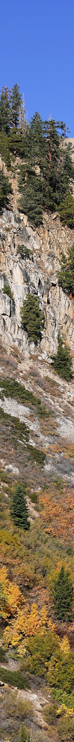
Only 7 hours of restless sleep due to excessive hiking Friday. Up before sunrise, Saturday October 17, 2020, left Forester along Upper Twin Lake at 7:45am. Temperature at campsite had been 27F again while 31F at the upper lake inlet while smoke haze was gone replaced with clear air and blue skies. I was at the bottom of the hanging valley face into Blacksmith Creek canyon about 8am. Am including more detail on this route to encourage others up to a convenient obstacle course challenge to match this old septuagenarian. The initial main use path up 100 feet or so is easy to follow. The slope above is dominated by Douglas fir with much tree debris and loose soft duff soil making for unstable travel and much climbing over branches and small logs. At 7300 is a long traverse right west across wood debris with a use route not obvious. Then pay attention to following a maze of main use path signs working up steep slopes with much zigzagging to avoid obstacles. All class 2 with much hand grabbing of trees, rocks, and logs to pull oneself up. At maybe 7700 one can see a steep bouldery section full of chinquapin. Faint use path go way left east towards creek into open trees for a bit and then enters aspen, willow, creek dogwood, horsetail thickets. Increasingly impossible to monkey through and obviously fewer and fewer tried continuing through. After reaching maybe 7900, I climbed back down about 100 feet to the west outside the jungle then traversed across the thicket jungle to reach east of creek below tall dense shadowy conifers amid large boulders buried in duff with Labrador tea below. Tall dense aspen, dogwood, and conifers block any view. Explored up bench to 8500 then crossed modest stream onto large boulder piles where there are open poor oblique perspectives of the aspen, willow, dogwood slope as seen from Upper Twin Lakes. Explored further up canyon to south end of the bench where the creek and upper canyons split but vegetation and trees still blocked any worthwhile clear photos of peak 11500.
Climbed up through a seep above a group of aspen to dry open forest slopes then began traversing back north while looking for openings in forest able to see leaf color slopes. Steep loose slope like on climb up, was tricky to traverse requiring careful dynamic foot placements. I came upon first opening southeast of the leaf color slope with a narrow 60mm view and took my A6000 camera out pack for first time on trip. Otherwise had been hand carrying the big tripod the whole times sans camera. Shot this single frame image of Victoria Peak at 11700 at page top or a full 3.7k above this tripod position. It has a nice geometric aesthetic with rusty metamorphic peak in the background with a slanting slice of granitoid cliffs with trees on ledges complementing the leaf color foreground slope. Also captured in the frame is a bird in flight at the upper left frame corner. Note previous images and other info shots were captured with my tiny Canon ELPH 190.

SZ02556-02595-2x2v 7800x6000 pixels 4 frame 2 column 2 row 40 image focus stack stitch blend A6000 60mm
enlarged vertical slice view
Continued on and after descending around some bedrock found this open spot per 2x2 60mm image above for more direct closer view of the colorful leaf slope of quaking aspen, Populus tremuloides, creek dogwood, cornus sericea ssp. sericea, chinquapin, Castanopsis sempervirens, and a willow species. Note at mid frame just left of dark purple creek dogwood, is a flowing seep across rock. All the yellow and orange leaves are aspen while yellow-green a willow, and green chinquapin. Many Sierra juniper, Juniperus grandis, on rocky face plus jeffrey pine, Pinus jeffreyi, red fir, Abies magnifica, including some young nicely silvery young trees.
I carefully climbed down step by step from the steep slope and this is where the long tripod helped stabilize stepping down. Instead of taking the unpleasant route down I climbed up, I followed down east of Blacksmith Creek to about 7.7k that was relatively open, easier than on the west. But then at a steeper drop, veered right east a long ways across small talus before dropping down into steep forest about 150 feet where I then found a faint diagonaling deer trail. That amazingly went all the way to the bottom at Mono Village at a more gradual angle. A better way up but would not be easy to find at the bottom. By 12:15pm was back at camp a few minutes after bros arrived. They had driven up to the Virginia Lakes where he didn't do that much fishing. Everywhere was overrun by Saturday weekend folks from SoCal. Heck he already had the big trout in the ice chest waiting to be fried and that we did for the second time. Again delicious! Before lunch I managed to take a nice refreshing dip in chilly Robinson Creek, washing away the considerable sweat and dust from my morning Blacksmith Creek canyon adventure.

SZ02629 4000x2667 pixels 1 frame 1 image A6000 SEL55210 @194mm
enlarged vertical slice view
In the afternoon we had a pleasant hike up to foot wide Labrosse Creek that has an idyllic shaded grassy section. Along the way in the open sagebrush flat, I pulled out my Sony SEL55210 telephoto zoom lens for the above single shot of the 8.5 mile distant Sawtooth Crest with Matterhorn Peak at 12279 feet at center. Given the clear atmosphere, it nicely rendered the blue wavelength Rayleigh scattering of ridges with increasing distance.

SZ02659-77 6000x3900 pixels 1 frame 19 image focus stack blend A6000 60mm
enlarged vertical slice view
Back at camp I wandered over to shoot an most unusual mushroom family that had poked up right through road surface gravel on the side of a campground road with scattered jeffrey pine needles and squirrel eaten cones. I had discovered these Halloween visitors the previous afternoon and made a couple sets of shots, however there were out of focus holes during post processing. Then successfully processed this second set I took late Saturday afternoon in shadowed skylight where I wisely mixed in some F14 apertures with wider depth of field to guaranty no soft areas. Back at camp we ate so much food, what a great time. Bros did drive late back up to Lower Twin Lake for his last shot of fishing. By time they returned I was nicely cozy prone in my back bed with all gear primed for a quick getaway in the morning.

SZ02700-02717-2x1v 6100x6000 pixels 2 frame 2 column 1 row 18 image focus stack stitch blend A6000 30mm
enlarged vertical slice view
We were all up, packed, saying goodbyes, and on the road before sunrise Sunday October 18, 2020. It was another clear atmosphere blue sky day without any smoke haze. As I went through Bridgeport, the temperature was a low 21F. I drove south on US395 back to Conway Summit at 8150 feet where although some Virginia Creek aspen grove areas looked more interesting 3 days later, they were not going to offer much. As sunrise began reaching the main grove at 8:45am, I rambled down off US395 through sagebrush that was showing a temperature of about 40F at the highway but down to the nearby grove it must have been mid 20F's within the cold sumping flow. I worked the above trees at the most orange section of trees where the open branches made for a modestly nice image with a nice blue sky showing through the lower branches. In better years one will see much more green mixed in.

SZ02722-37 5500x3900 pixels 1 frame 16 image focus stack blend A6000 30mm
enlarged vertical slice view
Before leaving since the sky was unusually beautiful deep blue above, worked this golden leaf tree that is a variation between more common light yellow and orange that had a nice canopy geometry.

SZ02741-51 4000x6000 pixels 1 frame 11 image focus stack blend A6000 30mm
enlarged vertical slice view
Within an hour had driven north on US395 then west on SR108 reaching the 8k Leavitt Creek grove that not many people ever explore because it is down below highway level, not so obvious driving by. But it is a nice area with well watered trees thus more likely to have vibrant fall leaves. I first worked the above single frame landscape with my 30mm lens of backlit quaking aspen providing an on fire look.

SZ02800-10 4000x6000 pixels 1 frame 11 image focus stack blend A6000 60mm
enlarged vertical slice view
After working the creek into a couple subjects that as expected turned out rather dim given shadows later in post processing, looked for a colorful wall section of perpendicular to camera position leaves I could fill my frame with and at 11am came upon this exceptional 60mm frame shooting across the creek between branches, the strongest material of the trip and one of my top photos this year of 2020. At tripod had to knock away a couple small dead aspen branches to clear the view. A breeze had been increasing that later required tedious manual post processing but the result is spectacular. Enjoy the leaf close-ups in the enlarged vertical slice view. This is an example of how well watered seep or permanent stream trees can still provide excellent healthy colored and veined detailed aspen leaf subjects even during worst drought conditions.

SZ02851-63 5800x4000 pixels 1 frame 13 image focus stack blend A6000 60mm
enlarged vertical slice view
West beyond Sonora Pass along SR108 below 7k, I stopped along a shaded vibrant patch of creeping snowberry, Symphoricarpos mollis, growing up through a matrix of fallen sugar pine needles. I waited out quiet between returning home weekend drivers speeding past on the highway shaking my subject with air concussion waves. Looked for a section with a mix of yellow and green leaves. Since it wasn't dead calm, this was another image that required much tedious processing frame by frame to eliminate mis-registration. After shooting 10 F14 and F8 shots and only 3 F5.6 shots, a breeze moved all the plants for the last 13 F5.6 sharpest shots that I deleted from the post processing focus stack blend set.

SZ02877-92 6000x4000 pixels 1 frame 16 image focus stack blend A6000 60mm
enlarged vertical slice view
Further along SR108, stopped quickly into a roadside pull-out after catching a glimpse of intense color about 150 feet above the road that I knew would be Pacific dogwood, Cornus nuttallii, that were now just coming into fall leaf color at its higher elevation limits. Since it was breezy, I chose to frame a section of leaves from lowest branches of the shrub laying right against an area of shaded breeze sheltered ground. Since I left my collapsible disks in the car, I used a sheet of blue plastic tarp supported by some propped up in the air dead branches to block the direct sun. Nicely was able to shoot of a set of shots at F11 then F8 but then again a breeze moved dogwood branches that during post processing I decided to leave out all the F5.6 shots from the Zerene Stacker stack. That worked out well though still spent maybe 6 hours post processing. The forest litter from sugar pine below the leaves are also all in sharp focus providing interesting detail. Note the bit of cyan hued fruticose lichen that fell atop the leaf frame right. And notice how the dogwood branches are red hued.
NEXT: Page 8 Santa Clara Valley
2020 Trip Chronicles: Contents