
QL04861-71 5200x4000 pixels 1 frame 11 image focus stack blend A6000 60mm
enlarged vertical slice view image text section
NEXT: Page 7 Carrizo Plain National Monument Monday 4/10
2017 Trip Chronicles: Contents
Joshua Tree National Park Monday 4/3 2of2
Joshua Tree National Park Tuesday 4/4
Joshua Tree National Park Wednesday 4/5
Carrizo Plain National Monument Thursday 4/6
By noon I had reached Bakersfield where I went into an Albertsons to buy some food, especially perishables. Then it was free wifi and gas at service station with a self serve wand car wash where for $2 I rinsed off a ton of dirty dust from the outside of the Forester. However under the hood would remain disgusting. The long drive east on SR58 continued across Tehachipi Pass to Mojave and to Barstow where I added a fresh block of ice to my heavy duty 28 quart cooler. By dusk had reached Yucca Valley where I slipped out on a lonely road I could tell others had been using to park overnight on the sly.
The following link below is to an online topo map for the monument.
mapper.acme.com
Change to the Satellite or Map tabs for other views and use the + - controls upper left to zoom in or out. The following link is to the NPS web page:
Joshua Tree National Park
A sluggish start on Monday April 3, 2017 had me entering JT via the Twentynine Palms northeast entrance mid morning. I had studied topographic maps, my guide books, and online information sources while recovering from the flu so had some idea of what I wanted to do. Early March drove through the park getting in 4 solid days of productive wildflower landscape work about Cottonwood Bajada at the southern side of the park and in 2005 had spent a few days hiking various areas but the park is enormous so there were vast areas I was unfamiliar about. Precipitation over the rainy season had been above normal but not comparable to biggest years. Also I was a bit late to be working areas I had interest in because of my illness. Thus not as great areas of spring annuals, probably a bit dry looking not optimal for larger landscapes, however it would be closer to the cactus peak I was particularly interested in. In any case would offer a chance to explore and get to know this wonderful park more while conditions at Carrizo were best left alone.
Monday mid morning there were few vehicles on the Pinto Basin Road, as I slowly drove down the primary north to south JT highway surveying vegetation and color roadsides. After dropping down several miles into upper Pinto Basin areas that had already become too dry and brown, I turned around and drove back up to the 2600 foot elevation where my topo analysis had expected plants due to winds from the below basin would tend to concentrate annual seeds. A minor breeze was blowing that would crimp my close-up work.

QL04458-64 6000x4000 pixels 1 frame 7 image focus stack blend A6000 60mm diffusion disk
enlarged vertical slice view
Was soon off on an exploratory excursion that started by popping through a low saddle that hid from highway view areas beyond. At the saddle atop broken small rocks of quartz monzanite geology grew some spectacular belly flowers per image above, Great Basin langloisia aka lilac sunbonnet, Langloisia setosissima. Note the spiny points on the bristly leaves. The pretty white hued flowers below are desert star, Monoptilon belloides.


Venturing down into the wash set up the above image of slopes of California brittlebush, Encelia californica, that were at peak. Scattered about on the light brown geology fractured small rock atop bedrock landscape were many other species including whitebract blazing star, phacelia, poppies, desert star, desert chicory, desert pincushion, plus several perennial bushes in bloom. However as I had found out at Death Valley, the previous year during the bloom there, it is rather difficult to capture strong landscapes of sparse flowers atop a bright light brown and white rock geology. At full detail size these landscapes are more reasonably aesthetic and interesting but worse when downsized to web sizes, detail of small plants blurs uselessly into the harsh light of brown rocks.

My Trimble app recorded 3.8 miles as I ventured a mile and one half up the large wash that I found quite interesting, taking a few sets of images despite the breeze, that later at home upon processing as expected, simply had too much plant movements for focus stacking. At a downsized web size, the image at right of a brittlebush flower against cactus looks acceptable. However at the full sizes I am capturing, petal movements between focus stack captures upon Photoshop or any other processing application will cause lots of artifacts on the fine details per crop at left.
After returning, drove back north then west on Park Blvd over Sheep Pass, on out to Keys View where the lot was nearly full. I parked in pleasant 63F temperatures to make lunch then pass an hour reading a couple of issues of Time magazine I'd brought along. By that time the forecast wind event had arrived so I needed to find something else productive to do beside camera work. About 3pm with the harsh sun waning, I drove back to Sheep Pass then set out on what would be a 3.4 mile cross country ramble about some picturesque rock formations. I also scouted out some Joshua trees for late dusk light images some day. With sunset and dusk light mediocre and all the in park campgrounds hopelessly full all week, I drove north out of the park then several miles east of Twentynine Palms, to disperse park on open BLM lands overnight.

Hoping Tuesday would be more productive, I was up and into the park early on Tuesday April 4, 2017. It was still somewhat breezy so instead of frustrating myself watching flower petals move around, I would do more exploring. Thus drove south down the dirt Geology Tour Road to areas with interesting boulder outcrops out in the landscape. I spent the morning hiking several miles around those areas that though 3-dimensionally interesting, offered little in color for a strong image. A list of wildflowers species were about sparsely.
Generally the Joshua tree plateau areas with lots of trees had sparse wildflowers other than an abundance of tiny yellow belly flowers of two species, Wallace's woolydaisy, Eriophyllum wallacei, and golden gilia, Linanthus aureus, that grew on bare soil areas like masses of goldfields. Thus one thing I learned is that about the higher elevation Joshua tree landscapes, there does not seem to be enough flower color to significantly impact landscape aesthetics. For that one needs to go down into Sonora Desert zones as I had done a month before or down to the Quail Springs Wash at the northwest end earlier. That said, there are sparse perennial cactus for foregrounds.
Late morning drove to the large Ryan Mountain trailhead parking lot that was near full of visitors, and set up the Forester for shade off the tailgate and a few hours of mid day lunch and relaxing. Cooked some Progresso Corn Chowder soup with my MSR Whisperlite stove and generally attacked my considerable bags of food while reading magazines as lots of cars and people on the Ryan trail came and went. By mid afternoon the wind event had slowed down enough that I decided to drive back to Wilson Canyon and hike into a couple other areas.

QL04760-68 5500x4000 pixels 1 frame 9 image focus stack blend A6000 60mm
enlarged vertical slice view
Mid afternoon I first hiked a couple miles about the main wash of Wilson Canyon along the highway at the 3100 foot elevation and found considerable worthwhile close-up subjects I might have worked in calmer conditions and some poppy and desert dandelion landscapes that would have been green and worthwhile a couple weeks earlier. With the breeze waning even more, I drove down to another large side canyon at 2900 feet, and at a small saddle found above a blindingly saturated Engelmann's hedgehog, Echinocereus engelmannii, cactus, the first strong image of my JT tour.

QL04769-77 5500x3000 pixels 1 frame 9 image focus stack blend A6000 60mm extension tube diffusion disk
enlarged vertical slice view

QL04821-26 6000x4000 pixels 1 frame 6 image focus stack blend A6000 60mm
enlarged vertical slice view
Excited about finding more cactus subjects, I rambled over a mile up the large wash and found a fine blooming California barrel cactus, Ferocactus cylindraceus. Lower left corner is a whitebract blazing star plant and at frame right a growing desert trumpet.


QL04834-42 4800x4000 pixels 1 frame 9 image focus stack blend A6000 60mm extension tube diffusion disk
enlarged vertical slice view
My final subject of the afternoon was back at the Engelmann's hedgehog cactus I had captured the whole plant of on my hike in. This time per above put on my extension tube for a close-up of the best flower on the plant being very careful to select all necessary focus positions. The nearer one gets to a close-up subject, the more difficult it becomes to focus stack obtaining all areas in sharp focus. One learns from failures of almost capturing subjects except for maybe one or two small area that were never focused adequately.
On my final day at JT, I wanted to work areas along the northwest part of Park Blvd I'd visited in 2005 so drove back out to Yucca Valley and made camp near where I had done so Sunday evening. Weather wind forecasts showed Thursday April 6 to possibly have light enough winds at Carrizo though might be cloudy with the approach of a system aiming north that would brush the area.

On Wednesday April 5, 2017 drove into the park early noting best wildflowers were in the Quail Springs Wash zone and went right up to the popular Hidden Valley area. I walked about the Joshua tree plateau just east trying to frame up a combination of the impressive rock towers in the background with trees up in the sky, and some of the golden gilia below on the ground. There were bands of high clouds in the sky that made stitch blend frame exposures variable. The above image was modestly successful. One will note the considerable dark green ephedra shrubs on the ground tend to overpower any positive value the yellow gilia add to the scene.
Another reason for working this area is that I had seen Mojave mound cactus, Echinocereus mojavensis, along the road on the drive out Tuesday. The species has a most lovely hue of deeply saturated slightly orange red. I thus worked the cactus image at page top, on the drive in. Framing up this composition was a puzzle because all the flowers were at sides of the frame with just the cactus spines elsewhere. However I noticed the spines themselves provided a fine background pattern to the strong petal colors. Note I was careful to get everything in the frame, even the gravels below in sharp focus.

QL05084-05108-4x1v 11700x6000 pixels 4 frame 4 column 1 row 25 image focus stack stitch blend A6000 30mm
enlarged vertical slice view
Anchored by a big green ephedra aka Mormon tea, Ephedra viridis, bush at the lower center frame edge, the above image worked better than the above Hidden Valley ridge image and includes a nice Mojave mound cactus. There are also 2 other blooming cactus plants in this view. The ephedra were not overwhelming, nicely spaced with greener nicely spaced gravel flats between dappled with numbers of small flowers. A nice graphic balance with Joshua trees, Yucca brevifolia, isolated against the blue skies at each end of the rock formation. To the left frame edge in front of the whale shaped boulder are several Mojave yucca, Yucca schidigera. Another cactus at center frame is a pencil cholla.

QL05138-45 3900x4200 pixels 1 frame 8 image focus stack blend A6000 60mm diffusion disk
Stopped along Park Blvd a couple more times. Spent quite some time gymnastically holding my disks blocking breezes trying to shoot the above mix of California desert dandelion, Malacothrix californica, apricot mallow, Sphaeralcea ambigua, and wild canterbury bells aka California bluebell, Phacelia minor. Marginally managed to get the above image. Great subject as the 3 together were unusual.

QL05358-05373-1x2v 4000x9700 pixels 2 frame 1 column 2 row 16 image focus stack stitch blend A6000 60mm
enlarged vertical slice view image text section image below right
Next spent a unproductive hour hiking way out into the Quail Springs Wash where from the road it appeared to this person's eyes that there were blue flowers a mile out yonder. But when i reached the area, it was only blue sky color reflecting of the bare branches of some dormant shrub species. Back in the Subaru for the last time in the park I sped down out of the park and continued north to Barstow to SR58 then back over Tehachipi Pass to Bakersfield where I stopped a bit again for supplies and a final wifi weather wind forecast check before continuing west over the Temblor Range and back into Carrizo Plain National Monument by mid afternoon.
Clouds of dust and dirt were still in the air above Elkhorn Road as I drove south surveying color in hills to the east. At the main canyon cars were stopping at, were about two dozen vehicles since each day social media and word of mouth from earlier visitors brought even more people into the park. Along the way, I took a good look at my next target canyon and then continued on then off on a familiar dirt spur road to legally disperse camp at.
Thursday April 6, 2017 would be my last day on the road trip as NWS forecasts were showing yet another winter front would be brushing the area on following days causing considerable wind. Dawn skies held a solid blanket of clouds to the west but with some open skies to the southeast. However as I drove back north, any open skies were pushing further east. I parked, got my gear together, started the Trimble Navigation app and struck out across drying brown jungles of fiddleneck to the mouth of my target canyon. In 2010 I was thwarted from capturing strong images in another canyon with my 4x5 view camera on a thick clouded day much like this. Although such diffuse light is beneficial for some types of subjects, that is not so for wildflower landscapes because the result lacks contrast that no amount of jacking Photoshop controls can fix even if someone was of a mind to do so. In other words with imagery one cannot invent usable detail where little exists. Additionally some wildflower species may not open up. That related, at mid day if overhead clouds thin enough but not so much as to cast shadows, some workable diffuse light can occur.
My target canyon slopes with color could barely be seen from road areas thus were not going to attract adventurous visitors for visual reasons. The route was not a pleasant walk. I could see where grazing cattle had gone up a short distance above the mouth, but beyond that were obstacles to inhibit further travel like dry falls, narrow canyon bottoms full of broken rock debris, and unpleasant saltbush blocking the way that required awkwardly climbing up and around often on steep side slopes. Great! I was going someplace difficult to reach. The canyon branched a few times and without my GPS track down on the canyon bottom it would be somewhat confusing knowing exactly which one I was climbing up. Since it was too dim and cloudy during early morning to consider working any areas, I explored up two main canyons. The first canyon had a sulfurous smelling San Andreas fault seep that occur in some of these western canyons. My route ended in a dry fall cascade that I thought would go if I persisted but rather turned around and backtracked in order to visit the other canyon that I expected had more color. Fifteen minutes later was back at the junction and then proceeded up that canyon where indeed there was much better color up ahead.

QL05218-05252-3x1v 6600x6000 pixels 1 frame 6 image focus stack blend A6000 30mm
enlarged vertical slice view
After reaching the canyon's headwall basin, I backtracked down to a shallow side ravine that could be climbed up to reach a view point down canyon above. About 10am with the sun more overhead offering stronger diffuse light but variable breezes increasing, began shooting. In the foreground are hillside daisies with desert candles across the ravine. Further away on that hillside were San Joaquin blazingstar, tansy phacelia sprinkled with poppies and Kern mallow at the canyon bottom, with a full mix of species beyond on canyon walls. In the distance was Old Potato Lake and the Caliente Range. Above in the sky upper right are a couple turkey vultures circling on updrafts, a species I seem to be capturing in several of my Temblor Range images.

QL05278-05295-2x1v 6900x6000 pixels 2 frame 2 column 1 row 18 image focus stack stitch blend A6000 30mm
enlarged vertical slice view
One of the reasons I explored into this particular canyon is from the topographic map, I could see that there were possible views up and down a length of canyon. I dropped down on steep canyon slopes for a view up the canyon with a large patch of orange hued San Joaquin blazingstar, Mentzelia pectinata, in the foreground and awesome colors all about. I had tried to work a similar image higher up near the ridgeline but breezes were already too consistent. By moving down in the canyon more, there was more chance for variable lulls as winds would be more erratic due to the topography. At this point I had found some exceptional subjects I knew would provide better color on a calm blue sky day about 10am shooting with my 60mm lens so began considering a return trip as soon as a workable weather day presented itself. But that could not be too many days into the future lest the current view of flowers wither away. So was determined while I was here to patiently work a final couple subjects to at least have something to show this year and would just use my 30mm to make that possible.

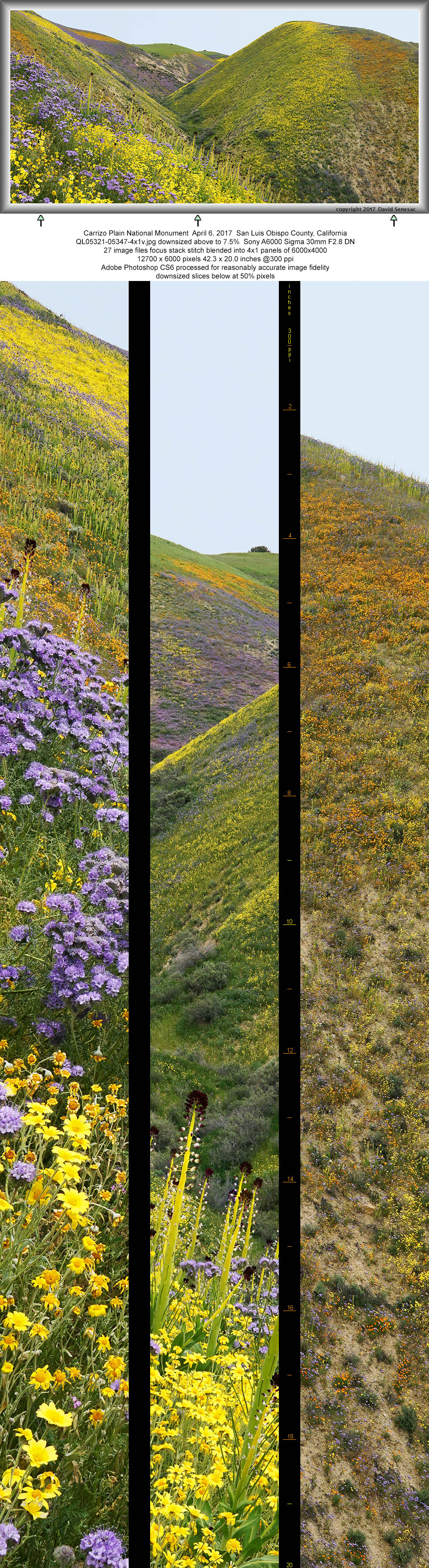
QL05321-05347-4x1v 12700x6000 pixels 4 frame 4 column 1 row 27 image focus stack stitch blend A6000 30mm
enlarged vertical slice view
The final landscape was this other worldy colorful view, a 4 wide panorama with my 30mm lens. Exposure was rather tricky because as the sun went between different cloud layers, brightness would change. Accordingly started and stopped the stitch sequence a few times. Patience paid off as I cranked off many shots on the difficult near frames at left during a single longer period when breezes nulled. Was happy to see that through and then was on my way back down.
Along the way ventured up a short ravine with dense areas of beautiful Kern mallow, Eremalche parryi ssp. kernensis, where I shot a close-up, the fourth image above.

QL05398-02 3900x5700 pixels 1 frame 5 image focus stack blend A6000 60mm
enlarged vertical slice view
Before reaching my car and driving home since my Trimble app was to show a long tiring 6.8 miles of hiking on this challenging route, I decided to spend a restful hour down near the mouth in a nice side canyon with a clean sandy wash area out of sight of the road, I'd seen in order to relax a bit and eat lunch as I had been so busy, not much of the food I'd been carrying had been eaten. After doing so I explored the small area where I saw several species uncommon further up in the Temblor, thistle sage, snakeheads, chick lupine, chia, globe gilia, chinese houses, and owl's clover. There were also dense patches of alkali goldfields, Lasthenia ferrisiae, that are most common down at Soda Lake. Shot the above image of what are one of our tallest goldfield species that otherwise tend to be rather short.
It was 4pm when I got back to my Forester and did not waste time getting back north up to SR58 after which is was a familiar long 4 hour drive home. A most successful week long spring wildflower road trip however I did have a strong reason to return to the canyon just visited as soon as weather cooperated.
NEXT: Page 7 Carrizo Plain National Monument Monday 4/10
2017 Trip Chronicles: Contents